


 |
市场调查报告书
商品编码
1671874
航空影像市场按应用、最终用途产业和地区划分Aerial Imaging Market, By Application, By End-use Industry, By Geography |
||||||
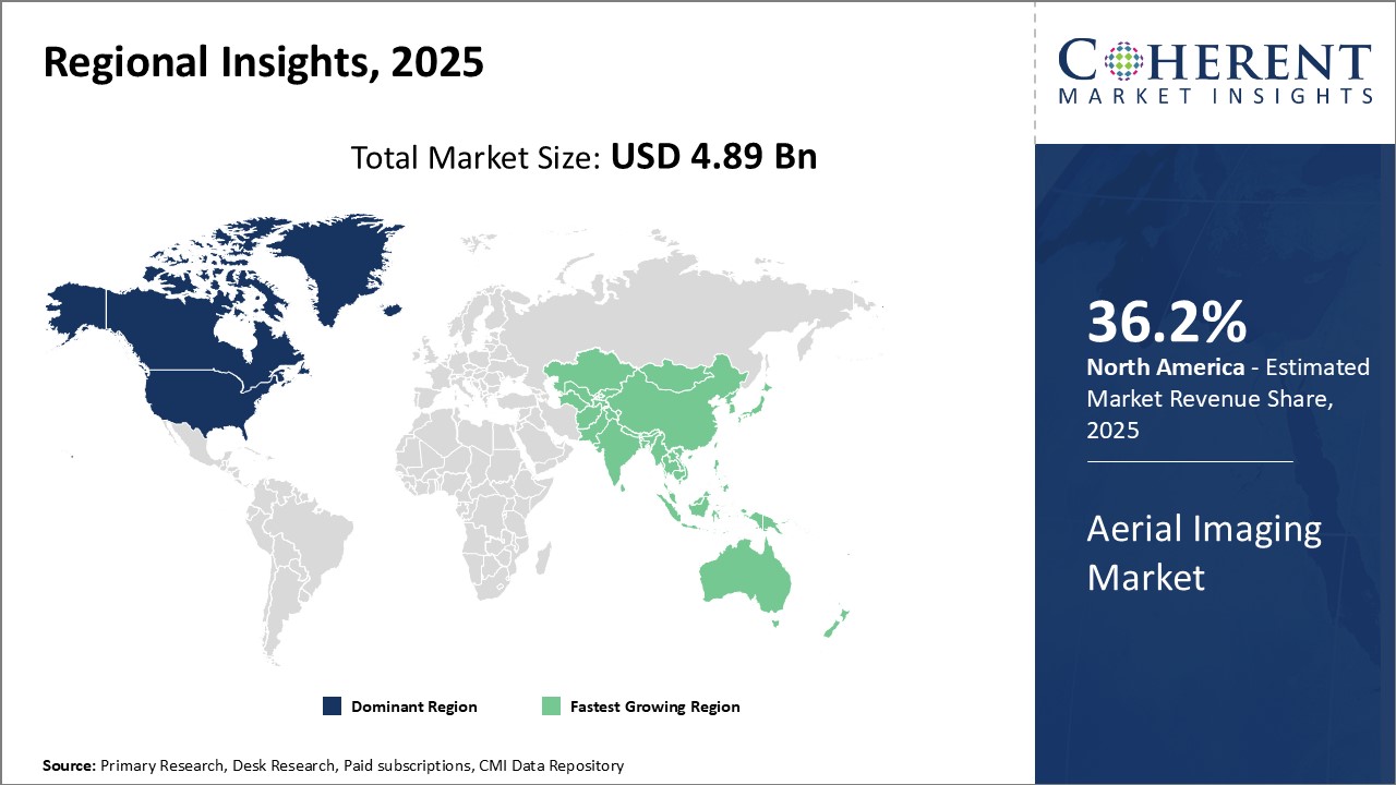
2025 年全球航空成像市场规模估计为 48.9 亿美元,预计到 2032 年将达到 145.9 亿美元,2025 年至 2032 年的年复合成长率(CAGR)为 16.9%。
| 报告范围 | 报告详细信息 | ||
|---|---|---|---|
| 基准年 | 2024 | 2025 年市场规模 | 48.9亿美元 |
| 效能资料 | 2020-2024 | 预测期 | 2025-2032 |
| 预测期:2025-2032年复合年增长率: | 16.90% | 2032 年价值预测 | 145.9亿美元 |
航空成像市场是指使用安装在飞机、无人机、直升机、气球和其他航空系统上的摄影机从高处拍摄地面照片和影片的技术和服务。这张航空影像提供了地形的鸟瞰图,广泛应用于农业、建筑、纪录片製作、能源和资源管理、环境监测、影视製作、社区和科学、政府、媒体和娱乐、采矿、房地产和旅游等行业。航空成像可以在传统地面方法所需时间的一小部分内监测大面积区域,并提供高解析度影像以供详细分析。
市场动态:
全球航空成像市场受到多种因素的推动,例如对空间资料和地图应用的需求不断增加、精密农业的兴起、建筑和基础设施开发活动的不断增长以及无人机影像处理的采用。然而,对无人机商业用途的严格监管以及与未经授权的空中监视相关的隐私问题阻碍了市场的成长。人工智慧影像分析解决方案的开发和整合先进感测器的无人机的采用提供了巨大的成长机会。环境监测、监视和测试领域的应用不断扩大也将推动需求。
本研究的主要特点
- 本研究报告对全球航空影像市场进行了详细分析,并提供了预测期(2025-2032)的市场规模和年复合成长率(CAGR%),假设 2024 年为基准年。
- 它还强调了各个领域的潜在收益成长机会,并说明了该市场的引人注目的投资提案矩阵。
- 它还提供了对市场驱动因素、限制因素、机会、新产品发布和核准、市场趋势、区域前景以及主要企业采用的竞争策略的重要见解。
- 报告根据公司亮点、产品系列、关键亮点、财务表现和策略等参数,概述了全球航空成像市场的主要企业。
- 本报告的见解将使负责人和公司经营团队能够就未来的产品发布、类型升级、市场扩张和行销策略做出明智的决策。
- 本研究报告针对该产业的各个相关人员,包括投资者、供应商、产品製造商、经销商、新进业者和财务分析师。
- 相关人员可以透过用于分析全球航空成像市场的各种策略矩阵更轻鬆地做出决策。
目录
第一章 调查目的与前提条件
- 研究目标
- 先决条件
- 简称
第二章 市场展望
- 报告描述
- 市场定义和范围
- 执行摘要
- Coherent Opportunity Map(COM)
第三章市场动态、法规与趋势分析
- 市场动态
- 驱动程式
- 限制因素
- 市场机会
- 监管情景
- 产业趋势
- 合併和收购
- 新系统实施/核准
- 新冠肺炎疫情的影响
第 4 章。
- 活力
- 地理空间技术
- 自然资源管理
- 建设与发展
- 灾难应变管理
- 国防和情报
- 保护与研究
- 媒体与娱乐
5. 2020 年至 2032 年按最终用途产业分類的全球航空影像市场
- 政府
- 商业企业
- 土木工程业
- 军队
- 林业和农业
- 能源领域
- 保险
6. 2020 年至 2032 年全球航空影像市场(按地区)
- 北美洲
- 欧洲
- 亚太地区
- 拉丁美洲
- 中东和非洲
第七章 竞争格局
- 公司简介
- 3D Robotics
- Aerial Imaging Productions, LLC
- Aerobotics,(Pty)Ltd.
- Airobotics GmbH
- Blom Norway AS
- Cooper Aerial Surveys Co.
- Datumate
- Digital Aerial Solutions, LLC
- Drone Deplay, Inc
- Eagle Aerial Solutions
- EagleView Technologies, Inc.
- Fugro NV
- GeoVantage, Inc.(Aeroptic, LLC)
- Global UAV Technologies Ltd
- Kucera International Inc.
- Landiscor Real Estate Mapping
- Nearmap Ltd.
- PrecisionHawk
- SkyIMD, Inc.
- SZ D JI Technology Co. Ltd
- Terra Flight Aerial Imaging Inc.
- Verisk
第 8 章 命运之轮
- 命运之轮
- 分析师观点
- 一致的机会图
第 9 章 章节
- 参考
- 调查方法
Global Aerial Imaging Market is estimated to be valued at USD 4.89 Bn in 2025 and is expected to reach USD 14.59 Bn by 2032, growing at a compound annual growth rate (CAGR) of 16.9% from 2025 to 2032.
| Report Coverage | Report Details | ||
|---|---|---|---|
| Base Year: | 2024 | Market Size in 2025: | USD 4.89 Bn |
| Historical Data for: | 2020 To 2024 | Forecast Period: | 2025 To 2032 |
| Forecast Period 2025 to 2032 CAGR: | 16.90% | 2032 Value Projection: | USD 14.59 Bn |
Aerial imaging market refers to the technology and services that capture photographs or videos of the ground from an elevated perspective using cameras mounted on aircraft, drones, helicopters, balloons, or other airborne systems. This airborne imagery provides bird's eye view of the terrain and has wide applications in agriculture, construction, documentary filmmaking, energy and resource management, environmental monitoring, film & television production, geography & science, government, media & entertainment, mining, real estate & tourism, and other industries. Aerial imagery allows the monitoring of large areas in a fraction of time compared to traditional ground-based methods and offers high-resolution images suitable for detailed analysis.
Market Dynamics:
The global aerial imaging market is driven by factors such as an increasing demand for spatial data and mapping applications, rise of precision agriculture, growing construction and infrastructure development activities, and adoption of drone-based imaging. However, strict regulations surrounding the commercial use of drones and privacy issues associated with unauthorized aerial surveillance hinder the market growth. Development of AI-powered image analysis solutions and adoption of drones integrated with advanced sensors present significant growth opportunities. Expanding applications in environment monitoring, surveillance, and inspections also propel the demand.
Key features of the study:
- This report provides an in-depth analysis of the global aerial imaging market, and provides market size (US$ Billion) and compound annual growth rate (CAGR %) for the forecast period (2025-2032), considering 2024 as the base year.
- It elucidates potential revenue growth opportunities across different segments and explains attractive investment proposition matrices for this market.
- This study also provides key insights about market drivers, restraints, opportunities, new product launches or approvals, market trends, regional outlook, and competitive strategies adopted by key players.
- It profiles key players in the global aerial imaging market based on the following parameters - company highlights, products portfolio, key highlights, financial performance, and strategies.
- Key companies covered as a part of this study include 3D Robotics, Aerial Imaging Productions, LLC, Aerobotics, (Pty) Ltd., Airobotics GmbH, Blom Norway AS, Cooper Aerial Surveys Co., Datumate, Digital Aerial Solutions, LLC, Drone Deplay, Inc, Eagle Aerial Solutions, EagleView Technologies, Inc., Fugro N.V., GeoVantage, Inc. (Aeroptic, LLC), Global UAV Technologies Ltd, Kucera International Inc., Landiscor Real Estate Mapping, Nearmap Ltd., PrecisionHawk , SkyIMD, Inc., SZ D JI Technology Co. Ltd , Terra Flight Aerial Imaging Inc., and Verisk.
- Insights from this report would allow marketers and the management authorities of the companies to make informed decisions regarding their future product launches, type up-gradation, market expansion, and marketing tactics.
- The global aerial imaging market report caters to various stakeholders in this industry including investors, suppliers, product manufacturers, distributors, new entrants, and financial analysts.
- Stakeholders would have ease in decision-making through various strategy matrices used in analyzing the global aerial imaging market.
Market Segmentation
- Application
- Energy
- Geospatial Technology
- Natural Resources Management
- Construction & Development
- Disaster Response Management
- Defense & Intelligence
- Conservation & Research
- Media & Entertainment
- End-use Industry
- Government
- Commercial Enterprises
- Civil Engineering Industry
- Military
- Forestry & Agriculture
- Energy Sector
- Insurance
- Region
- North America
- Europe
- Asia Pacific
- Latin America
- Middle East & Africa
- Key Players Insights
- 3D Robotics
- Aerial Imaging Productions, LLC
- Aerobotics, (Pty) Ltd.
- Airobotics GmbH
- Blom Norway AS
- Cooper Aerial Surveys Co.
- Datumate
- Digital Aerial Solutions, LLC
- Drone Deplay, Inc
- Eagle Aerial Solutions
- EagleView Technologies, Inc.
- Fugro N.V.
- GeoVantage, Inc. (Aeroptic, LLC)
- Global UAV Technologies Ltd
- Kucera International Inc.
- Landiscor Real Estate Mapping
- Nearmap Ltd.
- PrecisionHawk
- SkyIMD, Inc.
- SZ D JI Technology Co. Ltd
- Terra Flight Aerial Imaging Inc.
- Verisk
Table of Contents
1. Research Objectives and Assumptions
- Research Objectives
- Assumptions
- Abbreviations
2. Market Purview
- Report Description
- Market Definition and Scope
- Executive Summary
- Market Snippet, By Application
- Market Snippet, By End-use Industry
- Market Snippet, By Region
- Coherent Opportunity Map (COM)
3. Market Dynamics, Regulations, and Trends Analysis
- Market Dynamics
- Drivers
- Restraints
- Market Opportunities
- Regulatory Scenario
- Industry Trend
- Merger and Acquisitions
- New System Launches/Approvals
- Impact of COVID-19 Pandemic
4. Global Aerial Imaging Market, By Application, 2020-2032 (US$ Billion)
- Introduction
- Market Share Analysis, 2025 and 2032(%)
- Y-o-Y Growth Analysis, 2020-2032
- Segment Trends
- Energy
- Introduction
- Market Size and Forecast, 2020-2032, (US$ Billion)
- Geospatial Technology
- Introduction
- Market Size and Forecast, 2020-2032, (US$ Billion)
- Natural Resources Management
- Introduction
- Market Size and Forecast, 2020-2032, (US$ Billion)
- Construction & Development
- Introduction
- Market Size and Forecast, 2020-2032, (US$ Billion)
- Disaster Response Management
- Introduction
- Market Size and Forecast, 2020-2032, (US$ Billion)
- Defense & Intelligence
- Introduction
- Market Size and Forecast, 2020-2032, (US$ Billion)
- Conservation & Research
- Introduction
- Market Size and Forecast, 2020-2032, (US$ Billion)
- Media & Entertainment
- Introduction
- Market Size and Forecast, 2020-2032, (US$ Billion)
5. Global Aerial Imaging Market, By End-use Industry, 2020-2032 (US$ Billion)
- Introduction
- Market Share Analysis, 2025 and 2032(%)
- Y-o-Y Growth Analysis, 2020-2032
- Segment Trends
- Government
- Introduction
- Market Size and Forecast, 2020-2032, (US$ Billion)
- Commercial Enterprises
- Introduction
- Market Size and Forecast, 2020-2032, (US$ Billion)
- Civil Engineering Industry
- Market Share Analysis, 2025 and 2032 (%)
- Segment Trends
- Military
- Introduction
- Market Size and Forecast, 2020-2032, (US$ Billion)
- Forestry & Agriculture
- Introduction
- Market Size and Forecast, 2020-2032, (US$ Billion)
- Energy Sector
- Market Share Analysis, 2025 and 2032 (%)
- Segment Trends
- Insurance
- Introduction
- Market Size and Forecast, 2020-2032, (US$ Billion)
6. Global Aerial Imaging Market, By Region, 2020-2032 (US$ Billion)
- Introduction
- Market Share Analysis, By Region, 2025 and 2032 (%)
- North America
- Regional Trends
- Market Size and Forecast, By Application, 2020-2032 (US$ Billion)
- Market Size and Forecast, By End-use Industry, 2020-2032 (US$ Billion)
- Market Share Analysis, By Country, 2025 and 2032 (%)
- U.S.
- Canada
- Europe
- Regional Trends
- Market Size and Forecast, By Application, 2020-2032 (US$ Billion)
- Market Size and Forecast, By End-use Industry, 2020-2032 (US$ Billion)
- Market Share Analysis, By Country, 2025 and 2032 (%)
- U.K.
- Germany
- France
- Russia
- Rest of Europe
- Asia Pacific
- Regional Trends
- Market Size and Forecast, By Application, 2020-2032 (US$ Billion)
- Market Size and Forecast, By End-use Industry, 2020-2032 (US$ Billion)
- Market Share Analysis, By Country, 2025 and 2032 (%)
- China
- India
- Japan
- ASEAN
- Australia
- South Korea
- Rest of Asia Pacific
- Latin America
- Regional Trends
- Market Size and Forecast, By Application, 2020-2032 (US$ Billion)
- Market Size and Forecast, By End-use Industry, 2020-2032 (US$ Billion)
- Market Share Analysis, By Country, 2025 and 2032 (%)
- Brazil
- Argentina
- Mexico
- Rest of Latin America
- Middle East & Africa
- Market Size and Forecast, By Application, 2020-2032 (US$ Billion)
- Market Size and Forecast, By End-use Industry, 2020-2032 (US$ Billion)
- Market Share Analysis, By Country/Sub-region, 2025 and 2032 (%)
- South Africa
- GCC Countries
- Rest of the Middle East and Africa
7. Competitive Landscape
- Company Profiles
- 3D Robotics
- Company Overview
- Product Portfolio
- Financial Performance
- Key Strategies
- Recent Developments/Updates
- Aerial Imaging Productions, LLC
- Company Overview
- Product Portfolio
- Financial Performance
- Key Strategies
- Recent Developments/Updates
- Aerobotics, (Pty) Ltd.
- Company Overview
- Product Portfolio
- Financial Performance
- Key Strategies
- Recent Developments/Updates
- Airobotics GmbH
- Company Overview
- Product Portfolio
- Financial Performance
- Key Strategies
- Recent Developments/Updates
- Blom Norway AS
- Company Overview
- Product Portfolio
- Financial Performance
- Key Strategies
- Recent Developments/Updates
- Cooper Aerial Surveys Co.
- Company Overview
- Product Portfolio
- Financial Performance
- Key Strategies
- Recent Developments/Updates
- Datumate
- Company Overview
- Product Portfolio
- Financial Performance
- Key Strategies
- Recent Developments/Updates
- Digital Aerial Solutions, LLC
- Company Overview
- Product Portfolio
- Financial Performance
- Key Strategies
- Recent Developments/Updates
- Drone Deplay, Inc
- Company Overview
- Product Portfolio
- Financial Performance
- Key Strategies
- Recent Developments/Updates
- Eagle Aerial Solutions
- Company Overview
- Product Portfolio
- Financial Performance
- Key Strategies
- Recent Developments/Updates
- EagleView Technologies, Inc.
- Company Overview
- Product Portfolio
- Financial Performance
- Key Strategies
- Recent Developments/Updates
- Fugro N.V.
- Company Overview
- Product Portfolio
- Financial Performance
- Key Strategies
- Recent Developments/Updates
- GeoVantage, Inc. (Aeroptic, LLC)
- Company Overview
- Product Portfolio
- Financial Performance
- Key Strategies
- Recent Developments/Updates
- Global UAV Technologies Ltd
- Company Overview
- Product Portfolio
- Financial Performance
- Key Strategies
- Recent Developments/Updates
- Kucera International Inc.
- Company Overview
- Product Portfolio
- Financial Performance
- Key Strategies
- Recent Developments/Updates
- Landiscor Real Estate Mapping
- Nearmap Ltd.
- PrecisionHawk
- SkyIMD, Inc.
- SZ D JI Technology Co. Ltd
- Terra Flight Aerial Imaging Inc.
- Verisk
- 3D Robotics
8. Wheel of Fortune
- Wheel of Fortune
- Analyst View
- Coherent Opportunity Map
9. Section
- References
- Research Methodology
- About us and Sales Contact
 2026年全球直升机航拍摄影市场报告
 空拍图像提词器市场:按组件、平台、操作模式、应用和最终用户划分,全球预测,2026-2032年
 航拍摄影市场分析及预测(至2035年):类型、产品类型、服务、技术、组件、应用、最终用户、部署类型、设备2026年全球航拍摄影市场报告全球农业空中播种无人机市场(按无人机类型、作物类型、有效载荷能力、动力来源、最终用户和销售管道划分)预测(2026-2032年)全球航空反光膜市场(依产品类型、技术、应用、终端用户产业及通路划分)-2026-2032年预测
 航拍摄影市场-全球产业规模、份额、趋势、机会及预测,依平台类型、应用类型、最终用途类型、地区及竞争格局划分,2021-2031年预测
 航空影像市场规模、份额及成长分析(依平台、影像方式、应用、终端用户产业及地区划分)-2026-2033年产业预测2025年全球无人机屋顶冰雹损害扫描市场报告2025年全球无人机森林防火市场报告