


 |
市场调查报告书
商品编码
1773241
土地测量设备市场机会、成长动力、产业趋势分析及 2025 - 2034 年预测Land Survey Equipment Market Opportunity, Growth Drivers, Industry Trend Analysis, and Forecast 2025 - 2034 |
||||||
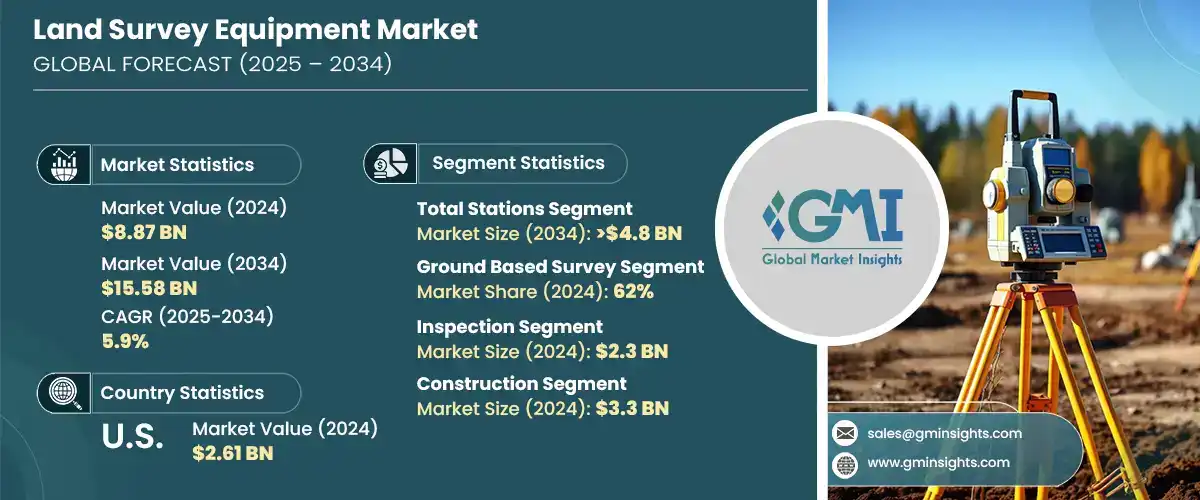
2024 年全球土地测量设备市场价值为 88.7 亿美元,预计到 2034 年将以 5.9% 的复合年增长率成长,达到 155.8 亿美元。农业、建筑、基础设施和采矿等行业对精确地理空间资讯日益增长的需求推动了这一增长。随着各行各业持续优先考虑效率、安全和精度,对下一代测量技术的需求日益增长。传统测量技术正迅速被 GNSS 接收器、机器人全站仪和 3D 雷射扫描仪等先进工具所取代。这些解决方案使测量人员能够更快、更准确地收集资料,从而改善地形测绘并更好地执行专案。从优化农业土地利用到提高采矿作业安全性,测量技术已成为众多应用中不可或缺的一部分。
如今,全球各行各业越来越意识到这些现代仪器为复杂的土地开发和规划专案带来的优势。这些先进的测量工具,例如全球导航卫星系统 (GNSS) 接收器、机器人全站仪和 3D 雷射扫描仪,提供无与伦比的精度、更快的资料收集和即时分析,有助于缩短专案工期并消除代价高昂的错误。从基础设施开发和交通规划到大规模农业和采矿作业,在极短时间内捕捉高解析度空间资料的能力彻底改变了专案的启动、管理和执行方式。建筑、公用事业和能源等行业也正在转向这些创新,以简化工作流程,提高测绘和建模的准确性,并遵守日益严格的安全和环境影响法规。
| 市场范围 | |
|---|---|
| 起始年份 | 2024 |
| 预测年份 | 2025-2034 |
| 起始值 | 88.7亿美元 |
| 预测值 | 155.8亿美元 |
| 复合年增长率 | 5.9% |
2024年,全站仪市场占据34.04%的市场份额,预计到2034年将达到48亿美元。全站仪整合角度和距离测量功能,使其在高精度测量中极具价值。其多功能性和成本效益使其成为各行各业的首选工具,尤其是在交通运输和城市基础设施建设领域。 GNSS相容性、无线连接和机器人自动化等最新创新正在简化工作流程并扩展其功能。
地面测量系统细分市场在2024年占据62%的市场份额,预计2025年至2034年的复合年增长率为5%。此类别涵盖传统和现代土地测量设备,例如全球导航卫星系统(GNSS)、水准仪和全站仪。其适应性、可靠性和便利性使其适用于广泛的专案范围,尤其是在建筑和城市规划等领域。地面测量在亚洲和欧洲等高成长市场中仍然至关重要,因为这些地区的大型城市基础设施持续推动需求。
2024年,美国土地测量设备市场占77.1%的市场份额,产值达26.1亿美元。北美在采用先进土地测量系统方面处于全球领先地位,这些系统包括人工智慧整合分析、3D扫描技术和基于无人机的测量工具。美国市场以其快速拥抱数位化而脱颖而出,尤其是在智慧基础设施和建筑数位化方面。 Hexagon和Trimble等公司透过持续投资于产品升级、研发和数位化转型,以满足日益增长的即时高精度资料需求,在塑造该地区技术格局方面发挥着重要作用。
影响土地测量设备产业的关键参与者包括 GeoTech、Hexagon、Topcon、Trimble、Stonex、DeepWell、FARO、Bosch Tools、Emlid Tech 和上海华测导航技术有限公司。土地测量设备市场的公司正在大力投资研发,以创造创新、多功能和高精度的解决方案,满足不断变化的产业需求。许多公司将人工智慧、物联网和无线技术整合到测量设备中,以增强自动化、即时资料处理和云端相容性。与建筑和基础设施公司的合作伙伴关係和策略合作也是扩大客户群的关键。参与者正强调开发紧凑、坚固且易于移动的设备,以应对偏远地区和城市测量的挑战。此外,公司正在本地化生产和支援服务,以更好地满足区域市场的需求,同时注重设备的可持续性和长期适用性。
目录
第一章:方法论与范围
第二章:执行摘要
第三章:行业洞察
- 产业生态系统分析
- 供应商格局
- 电子元件供应商
- 设备製造商
- 服务提供者
- 系统整合商
- 最终用途
- 成本结构
- 利润率
- 每个阶段的增值
- 影响供应链的因素
- 破坏者
- 供应商格局
- 对部队的影响
- 成长动力
- 全球基础设施繁荣推动对精确土地测量的需求
- GNSS、3D 扫描仪和无人机彻底改变了土地测量
- 农民和矿工利用测量技术进行精准作业
- GIS 扩展推动对勘测级地理空间资料的需求
- 产业陷阱与挑战
- GNSS 和 3D 扫描仪的高成本限制了小型测量公司的发展
- 技能差距阻碍了先进测量技术的采用
- 市场机会
- 政府土地评估授权维持测量需求
- 整合 AR/VR 以实现远端培训和即时调查协助
- 成长动力
- 成长潜力分析
- 波特的分析
- PESTEL分析
- 技术与创新格局
- 现有技术
- 高精度 RTK 和 PPK GNSS/GPS 系统
- 机器人和电动全站仪
- 3D雷射扫描仪中的地面和移动LiDAR
- 摄影测量与 LiDAR 测绘无人机/无人驾驶飞机
- 新兴技术
- 用于资料处理的人工智慧和机器学习
- 自主测量机器人
- 扩增实境 (AR) 用于现场可视化
- 用于安全地理空间资料管理的区块链
- 现有技术
- 专利分析
- 监管格局
- 北美洲
- 欧洲
- 亚太地区
- 拉丁美洲
- 中东和非洲
- 生产统计
- 生产中心
- 消费中心
- 汇出和汇入
- 成本細項分析
- 可持续性分析
- 永续实践
- 减少废弃物的策略
- 生产中的能源效率
- 环保倡议
- 碳足迹考量
第四章:竞争格局
- 介绍
- 公司市占率分析
- 北美洲
- 欧洲
- 亚太地区
- 拉丁美洲
- 中东和非洲
- 竞争定位矩阵
- 战略展望矩阵
- 关键进展
- 併购
- 伙伴关係与合作
- 新产品发布
- 扩张计划和资金
第五章:市场估计与预测:按产品,2021 - 2034 年
- 主要趋势
- 全站仪
- GPS/GNSS 系统
- 雷射扫描仪
- 等级
- 无人驾驶飞行器(UAV)/无人机
- 其他的
第六章:市场估计与预测:依调查方法,2021 - 2034 年
- 主要趋势
- 地面勘测
- 雷射勘测
第七章:市场估计与预测:按应用,2021 - 2034 年
- 主要趋势
- 检查
- 品质控制检查
- 结构检查
- 基础设施检查
- 监控
- 环境监测
- 土地利用监测
- 大地测量监测
- 对应
- 工程与设计
- 体积计算
- 土方计算
- 库存量计算
- 挖填体积计算
- 布置点
- 施工现场布置
- 管道和公用设施勘测
- 道路和高速公路布局
- 地理资讯系统(GIS)
- 土地开发规划
- 农业测量
- 其他的
第八章:市场估计与预测:依最终用途,2021 - 2034 年
- 主要趋势
- 建造
- 石油和天然气
- 矿业
- 实用工具
- 农业
- 国防和安全
- 其他的
第九章:市场估计与预测:按地区,2021 - 2034 年
- 北美洲
- 我们
- 加拿大
- 欧洲
- 英国
- 德国
- 法国
- 义大利
- 西班牙
- 俄罗斯
- 北欧人
- 亚太地区
- 中国
- 印度
- 日本
- 韩国
- 澳洲
- 东南亚
- 拉丁美洲
- 巴西
- 墨西哥
- 阿根廷
- 智利
- MEA
- 南非
- 沙乌地阿拉伯
- 阿联酋
第十章:公司简介
- Aptella
- Baseline Equipment Company
- Bosch Tools
- DeepWell
- Emlid Tech
- FARO
- GeoTech
- Guangdong KOLIDA Instrument
- Hexagon
- Hi-Target
- Juniper Systems
- Seiler Instrument Company
- Shanghai Huace Navigation Technology
- South Surveying & Mapping Technology Company
- Spectra Geospatial
- Stonex
- Suparule Systems
- Teledyne
- Topcon
- Trimble
The Global Land Survey Equipment Market was valued at USD 8.87 billion in 2024 and is estimated to grow at a CAGR of 5.9% to reach USD 15.58 billion by 2034. This expansion is driven by the growing need for accurate geospatial information across sectors such as agriculture, construction, infrastructure, and mining. As industries continue to prioritize efficiency, safety, and precision, demand for next-generation surveying technologies has gained momentum. Traditional surveying techniques are rapidly being replaced by advanced tools like GNSS receivers, robotic total stations, and 3D laser scanners. These solutions enable surveyors to collect data faster and more accurately, resulting in improved terrain mapping and better project execution. Surveying technology has become indispensable in multiple applications, from optimizing land usage in agriculture to enhancing operational safety in mining.
Industries around the world are now increasingly aware of the advantages these modern instruments bring to complex land development and planning initiatives. These advanced surveying tools, such as GNSS receivers, robotic total stations, and 3D laser scanners, offer unmatched precision, faster data collection, and real-time analytics, helping reduce project timelines and eliminate costly errors. From infrastructure development and transportation planning to large-scale agricultural and mining operations, the ability to capture high-resolution spatial data in a fraction of the time has revolutionized how projects are initiated, managed, and executed. Sectors like construction, utilities, and energy are also turning to these innovations to streamline workflow, enhance accuracy in mapping and modeling, and comply with increasingly stringent regulations around safety and environmental impact.
| Market Scope | |
|---|---|
| Start Year | 2024 |
| Forecast Year | 2025-2034 |
| Start Value | $8.87 Billion |
| Forecast Value | $15.58 Billion |
| CAGR | 5.9% |
In 2024, the total stations segment held a 34.04% share and is anticipated to hit USD 4.8 billion by 2034. Their integrated ability to measure angles and distances makes them highly valuable for high-precision work. Their versatility and cost-effectiveness make them a preferred tool across a range of sectors, particularly for transportation and urban infrastructure developments. Recent innovations such as GNSS compatibility, wireless connectivity, and robotic automation are streamlining workflow and expanding their capabilities.
Ground-based survey systems segment held a 62% share in 2024 and is expected to grow at a CAGR of 5% from 2025 to 2034. This category covers both traditional and contemporary land survey equipment like GNSS systems, levels, and total stations. Their adaptability, reliability, and accessibility make them suitable for a broad array of project scopes, particularly in sectors like construction and city planning. Ground-based surveys remain essential across high-growth markets in Asia and Europe, where large-scale urban infrastructure continues to drive demand.
U.S. Land Survey Equipment Market accounted for a 77.1% share in 2024, generating USD 2.61 billion. North America leads globally in adopting advanced land surveying systems, including AI-integrated analytics, 3D scanning technologies, and UAV-based survey tools. The U.S. market stands out for its fast embrace of digitalization, especially through initiatives in smart infrastructure and construction digitization. Companies like Hexagon and Trimble play a major role in shaping the region's technological landscape by continually investing in product upgrades, research, and digital transformation to meet the growing need for real-time, high-accuracy data.
Key players shaping the Land Survey Equipment Industry include GeoTech, Hexagon, Topcon, Trimble, Stonex, DeepWell, FARO, Bosch Tools, Emlid Tech, and Shanghai Huace Navigation Technology. Companies in the land survey equipment market are investing significantly in R&D to create innovative, multi-functional, and high-accuracy solutions that cater to evolving industry demands. Many are integrating AI, IoT, and wireless technologies into survey equipment to enhance automation, real-time data processing, and cloud compatibility. Partnerships and strategic collaborations with construction and infrastructure firms are also key to expanding client bases. Players are emphasizing the development of compact, rugged, and mobile-friendly devices to address remote and urban survey challenges. Additionally, companies are localizing production and support services to better cater to regional markets while focusing on sustainability and long-term serviceability of equipment.
Table of Contents
Chapter 1 Methodology & Scope
- 1.1 Research design
- 1.1.1 Research approach
- 1.1.2 Data collection methods
- 1.2 Base estimates & calculations
- 1.2.1 Base year calculation
- 1.2.2 Key trends for market estimation
- 1.3 Forecast model
- 1.4 Primary research and validation
- 1.4.1 Primary sources
- 1.4.2 Data mining sources
- 1.5 Market scope & definition
Chapter 2 Executive Summary
- 2.1 Industry synopsis, 2021 – 2034
- 2.2 Key market trends
- 2.2.1 Regional
- 2.2.2 Product
- 2.2.3 Survey method
- 2.2.4 Application
- 2.2.5 End Use
- 2.3 TAM Analysis, 2025-2034
- 2.4 CXO perspectives: Strategic imperatives
- 2.4.1 Key decision points for industry executives
- 2.4.2 Critical success factors for market players
- 2.5 Future Outlook and Strategic Recommendations
Chapter 3 Industry Insights
- 3.1 Industry ecosystem analysis
- 3.1.1 Supplier landscape
- 3.1.1.1 Electronic component suppliers
- 3.1.1.2 Equipment manufacturers
- 3.1.1.3 Service providers
- 3.1.1.4 System integrators
- 3.1.1.5 End use
- 3.1.2 Cost structure
- 3.1.3 Profit margin
- 3.1.4 Value addition at each stage
- 3.1.5 Factors impacting the supply chain
- 3.1.6 Disruptors
- 3.1.1 Supplier landscape
- 3.2 Impact on forces
- 3.2.1 Growth drivers
- 3.2.1.1 The global infrastructure boom drives demand for accurate land surveys
- 3.2.1.2 GNSS, 3D scanners, and drones revolutionize land surveying
- 3.2.1.3 Farmers and miners leverage survey tech for precision operations
- 3.2.1.4 GIS expansion fuels need for survey-grade geospatial data
- 3.2.2 Industry pitfalls & challenges
- 3.2.2.1 High costs of GNSS & 3D scanners restrict small survey firms
- 3.2.2.2 Skill gap hinders the adoption of advanced surveying technology
- 3.2.3 Market Opportunities
- 3.2.3.1 Government land assessment mandates sustain surveying demand
- 3.2.3.2 Integration of AR/VR for remote training and real-time survey assistance
- 3.2.1 Growth drivers
- 3.3 Growth potential analysis
- 3.4 Porter's analysis
- 3.5 PESTEL analysis
- 3.6 Technology & innovation landscape
- 3.6.1 Current technologies
- 3.6.1.1 High-precision RTK & PPK GNSS/GPS Systems
- 3.6.1.2 Robotic & Motorized Total Stations
- 3.6.1.3 Terrestrial & Mobile LiDAR in 3D Laser Scanners
- 3.6.1.4 Photogrammetry & LiDAR Mapping Drones/UAVs
- 3.6.2 Emerging technologies
- 3.6.2.1 AI & machine learning for data processing
- 3.6.2.2 Autonomous surveying robots
- 3.6.2.3 Augmented reality (AR) for field visualization
- 3.6.2.4 Blockchain for secure geospatial data management
- 3.6.1 Current technologies
- 3.7 Patent analysis
- 3.8 Regulatory landscape
- 3.8.1 North America
- 3.8.2 Europe
- 3.8.3 Asia Pacific
- 3.8.4 Latin America
- 3.8.5 Middle East & Africa
- 3.9 Production statistics
- 3.9.1 Production hubs
- 3.9.2 Consumption hubs
- 3.9.3 Export and import
- 3.10 Cost breakdown analysis
- 3.11 Sustainability analysis
- 3.11.1 Sustainable practices
- 3.11.2 Waste reduction strategies
- 3.11.3 Energy efficiency in production
- 3.11.4 Eco-friendly initiatives
- 3.11.5 Carbon footprint considerations
Chapter 4 Competitive Landscape, 2024
- 4.1 Introduction
- 4.2 Company market share analysis
- 4.2.1 North America
- 4.2.2 Europe
- 4.2.3 Asia Pacific
- 4.2.4 Latin America
- 4.2.5 Middle East & Africa
- 4.3 Competitive positioning matrix
- 4.4 Strategic outlook matrix
- 4.5 Key developments
- 4.5.1 Mergers & acquisitions
- 4.5.2 Partnerships & collaborations
- 4.5.3 New Product Launches
- 4.5.4 Expansion Plans and funding
Chapter 5 Market Estimates & Forecast, By Product, 2021 - 2034 ($Bn, Units)
- 5.1 Key trends
- 5.2 Total stations
- 5.3 GPS/GNSS systems
- 5.4 Laser scanners
- 5.5 Levels
- 5.6 Unmanned Aerial Vehicles (UAV)/Drones
- 5.7 Others
Chapter 6 Market Estimates & Forecast, By Survey Method, 2021 - 2034 ($Bn, Units)
- 6.1 Key trends
- 6.2 Ground-based surveys
- 6.3 Laser surveys
Chapter 7 Market Estimates & Forecast, By Application, 2021 - 2034 ($Bn, Units)
- 7.1 Key trends
- 7.2 Inspection
- 7.2.1 Quality control inspections
- 7.2.2 Structural inspections
- 7.2.3 Infrastructure inspections
- 7.3 Monitoring
- 7.3.1 Environmental monitoring
- 7.3.2 Land use monitoring
- 7.3.3 Geodetic monitoring
- 7.4 Mapping
- 7.5 Engineering & design
- 7.6 Volumetric calculation
- 7.6.1 Earthwork calculations
- 7.6.2 Stockpile volume calculations
- 7.6.3 Cut and fill volume calculations
- 7.7 Layout points
- 7.7.1 Site layout for construction
- 7.7.2 Surveying for pipelines and utilities
- 7.7.3 Road and highway layout
- 7.8 Geographic Information Systems (GIS)
- 7.9 Land development planning
- 7.10 Agricultural surveying
- 7.11 Others
Chapter 8 Market Estimates & Forecast, By End use, 2021 - 2034 ($Bn, Units)
- 8.1 Key trends
- 8.2 Construction
- 8.3 Oil & gas
- 8.4 Mining
- 8.5 Utilities
- 8.6 Agriculture
- 8.7 Defense & security
- 8.8 Others
Chapter 9 Market Estimates & Forecast, By Region, 2021 - 2034 ($Bn, Units)
- 9.1 North America
- 9.1.1 U.S.
- 9.1.2 Canada
- 9.2 Europe
- 9.2.1 UK
- 9.2.2 Germany
- 9.2.3 France
- 9.2.4 Italy
- 9.2.5 Spain
- 9.2.6 Russia
- 9.2.7 Nordics
- 9.3 Asia Pacific
- 9.3.1 China
- 9.3.2 India
- 9.3.3 Japan
- 9.3.4 South Korea
- 9.3.5 Australia
- 9.3.6 Southeast Asia
- 9.4 Latin America
- 9.4.1 Brazil
- 9.4.2 Mexico
- 9.4.3 Argentina
- 9.4.4 Chile
- 9.5 MEA
- 9.5.1 South Africa
- 9.5.2 Saudi Arabia
- 9.5.3 UAE
Chapter 10 Company Profiles
- 10.1 Aptella
- 10.2 Baseline Equipment Company
- 10.3 Bosch Tools
- 10.4 DeepWell
- 10.5 Emlid Tech
- 10.6 FARO
- 10.7 GeoTech
- 10.8 Guangdong KOLIDA Instrument
- 10.9 Hexagon
- 10.10 Hi-Target
- 10.11 Juniper Systems
- 10.12 Seiler Instrument Company
- 10.13 Shanghai Huace Navigation Technology
- 10.14 South Surveying & Mapping Technology Company
- 10.15 Spectra Geospatial
- 10.16 Stonex
- 10.17 Suparule Systems
- 10.18 Teledyne
- 10.19 Topcon
- 10.20 Trimble
 2026年全球土地测量设备市场报告
 土地测量设备市场规模、份额和成长分析(按解决方案、技术、应用、产业、最终用户、销售管道和地区划分)-产业预测(2026-2033 年)
 按产品类型、技术类型、操作模式、应用和最终用户分類的土地测量设备市场—2025-2032年全球预测
 土地测量设备市场规模、份额和趋势分析报告:2024-2030 年按组件、应用、最终用途、行业、地区和细分市场进行的预测
 全球土地测量设备市场预测(~2030):按产品、解决方案、技术、应用、最终用户和地区进行全球分析
 土地测量设备市场,占有率,规模,趋势,行业分析报告:依行业,解决方案,应用,最终用户,地区,细分市场预测2024-2032 年
 美国土地测量设备市场规模和预测、全球和地区份额、趋势和成长机会分析报告范围:按解决方案、行业和应用