


 |
市场调查报告书
商品编码
1403053
地理空间分析 -市场占有率分析、产业趋势/统计、2024 年至 2029 年成长预测Geospatial Analytics - Market Share Analysis, Industry Trends & Statistics, Growth Forecasts 2024 - 2029 |
||||||
※ 本网页内容可能与最新版本有所差异。详细情况请与我们联繫。
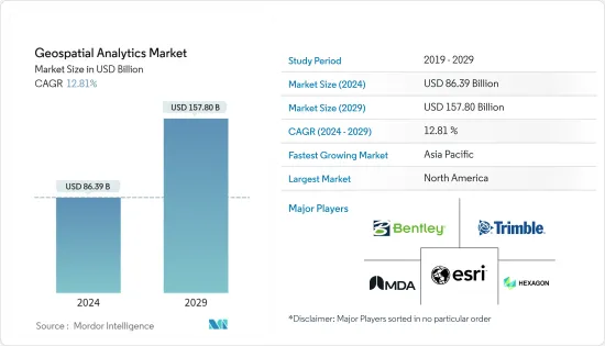
地理空间分析市场规模预计到 2024 年为 863.9 亿美元,预计到 2029 年将达到 1578 亿美元,在预测期内(2024-2029 年)复合年增长率为 12.81%。
主要亮点
- 区域分析操作、收集和显示地理资讯系统 (GIS)资料和影像,例如卫星和 GPS 影像。区域分析基于地理座标和特定识别码(例如街道和邮递区号)。
- 在这个资料主导的工业时代,使用互联技术(扩增实境、巨量资料、资讯、机器学习、物联网、3D技术)的位置和空间资料正在改变传统商业实践的核心,透过资料视觉化驱动竞争优势。消费者应用程式和企业层级对地理空间内容、即时资料和服务的需求持续成长。
- 5G还有望透过数位测绘和定位智慧技术帮助解决灾害管理和气候变迁等环境问题。 5G 和物联网的连接性、速度和容量预计将减少温室气体排放、提高能源效率并更好地利用可再生资源。 5G 预计也将有助于改善有关天气、植被和废弃物管理的决策,并增加对地理空间分析的要求。
- 一个驱动因素是人们对智慧城市发展的日益接受。地理空间分析解决方案已成为智慧城市发展的平台。地理资讯系统(GIS)已成为智慧城市日常生活的重要组成部分。 GIS 提供了IT基础设施,整合了从规划和设计到开发和维护的所有相关人员和所有智慧城市流程。
- 地理空间资料创建和分析广泛应用于政府、商业和科学领域。然而,位置资料固有的敏感性特征阻碍了地理空间研究及其社会应用。随着GIS及相关地理空间技术的使用增加,社会对隐私的担忧增加,政府法规限制资料收集、资讯共用、基于资讯的资讯使用和资料存储,事实就是如此。预计这将阻碍市场成长。
- COVID-19 大流行对地理空间分析市场的影响可以忽略不计,包括医疗机构和政府在内的许多公司在大流行期间采用地理空间技术进行製药和药物输送。使用地理空间分析对影响反应措施的因素进行分类。
- 然而,许多公司正在更新他们的解决方案,以自动化机器学习和人工智慧技术,以提供准确的见解。随着5G技术的出现,这种趋势在预测期内可能会持续增加。预计新的新兴企业将在不久的将来增加对地理空间分析市场的需求。
地理空间分析市场趋势
国防和情报将成为最大的最终用户产业
- 地理空间系统允许军队透过GIS技术识别部队和基地的位置以及重要的相关资讯。此技术用于国防土地管理,军队管理各级指挥的基地和分队。您可以追踪部队动向、寻找资源并规划任务。它也用于识别空对地轰炸任务的目标。它透过为指定的兴趣区域提供不同程度的地形细节来帮助军事目标识别。
- 国防和安全机构相关人员表示,地理空间资料在各种关键资料管理应用中发挥关键作用,包括灾害、军事行动、紧急管理、环境监测、土地和城市规划等。
- 此外,地理空间技术的进步使得以前所未有的精度绘製行星和其他天体地图成为可能,将来自卫星和探测器的资料和照片探勘为丰富的空间资讯。儘管太空人尚未踏上火星土壤,但科学家们正在藉助地理空间分析来熟悉火星地形的特殊性。
- 根据这些努力收集的空间资讯创建的行星地图和马赛克将提高我们对太空中遥远天体的地质、地形和景观的理解。美国地质调查局的天体地质科学中心提供了包括新视野号在内的各种任务收集的图像和资料,并向研究人员和公众开放。资料库包括月球、火星、冥王星、土星、水星等的影像,可使用地理空间分析技术进行进一步分析。
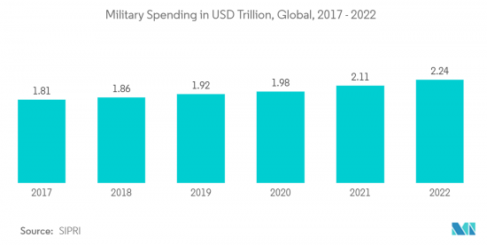
- 此外,政府在该领域的投资增加可能会在预测期内进一步推动研究市场需求。例如,根据SIPRI的数据,2022年全球军费支出达到2.24兆美元,创该时期最高水准。
北美占据主要市场占有率
- 美国和加拿大建设产业的成长预计将增加对 3D 测绘和建模的需求,预计在预测期内也将成长。施工过程使用复杂的 3D 绘图和地理空间分析来创建逼真的模型,这比使用滚动的蓝图更可取。这进一步推动了该地区的市场需求。
- 这就是为什么公司正在采用位置追踪解决方案来追踪和监控其员工以及他们接触的事物。此外,资讯分析有助于定义限制组织内团队之间沟通的空间边界。
- 2022 年 11 月,为物联网设备提供 5G 连接的美国微型卫星电信业者Sateliot 将在SpaceX Falcon 9 火箭上部署一颗功能性微型卫星,以加速大规模物联网部署。它已将物联网产业转向更便宜的全球连接,并带来创新相当于GPS的引入。 Sateliot旨在透过部署一个由小型、强大的卫星组成的网络,为世界每个角落,包括灾区、海洋和偏远地区提供全面可靠的覆盖来解决这些问题。此外,无论营运商如何,任何标准物联网设备都可以使用该技术。
- 例如,2022 年 11 月,AWS IoT Core 这项託管云端服务允许用户连接数十亿个 IoT 装置并将数兆个讯息路由到 AWS 服务,将推出 AWS IoT Core Device Location。这项进阶功能允许使用者使用纬度和经度座标等位置资讯来管理和追踪物联网设备。 Amazon Web Services IoT Core Device Location 让客户能够优化业务流程、简化维护并开拓新的使用案例。例如,您的现场服务团队可以随时资讯并轻鬆识别需要维护的设备。全球定位服务 (GPS) 是确定物联网应用中物联网设备位置的常用标准。
- 此外,云端基础的GIS 的快速采用以及 VR 和 AR 技术在地理资讯系统中的应用预计将对预测期内的市场成长产生重大影响。
地理空间分析产业概述
地理空间分析市场的特征是整合不断加强,多家主要企业在特定地区或国家占据主导地位。这些主要企业包括 ESRI Inc.、通用电气 (GE)、Hexagon AB、MDA Corporation、Bentley Systems, Inc.、Trimble Geospatial 等。这些产业巨头采用各种策略来保持竞争。
2023 年 7 月,国际太空技术供应商 Locana 与致力于支援和扩展 OpenStreetMap (OSM)计划的非营利组织 OpenStreetMap 美国联手。 OSM 旨在增强对高品质地理资料的访问,降低利用定位智慧的成本,并使更多组织能够利用定位资料提供的见解。
2023年2月,GE再生能源的电网解决方案业务赢得了尼泊尔电力局(NEA)价值数百万美元的合约。该合约包括尼泊尔各地 39 个不同额定功率的变电站的自动化。它还包括建造六个主控制中心(MCC),标誌着尼泊尔电力基础设施的重大发展。
其他福利
- Excel 格式的市场预测 (ME) 表
- 3 个月的分析师支持
目录
第一章简介
- 研究假设和市场定义
- 调查范围
第二章调查方法
第三章执行摘要
第四章市场洞察
- 市场概况
- 产业价值链分析
- 产业吸引力-波特五力分析
- 新进入者的威胁
- 买家/消费者的议价能力
- 供应商的议价能力
- 替代品的威胁
- 竞争公司之间的敌对关係
第五章市场动态
- 市场驱动因素
- 智慧城市发展的采用率不断提高
- 5G的引入推动市场成长
- 市场挑战
- 高成本和营运问题
- 法律障碍
- 评估 COVID-19 对地理空间分析市场的影响
第六章市场区隔
- 按类型
- 表面分析
- 网路分析
- 地理空间视觉化分析
- 按行业分类
- 农业
- 公共产业和通讯
- 国防/资讯
- 政府机关
- 自然资源
- 按行业分類的其他最终用户
- 按地区
- 北美洲
- 欧洲
- 亚太地区
- 拉丁美洲
- 中东/非洲
第七章竞争形势
- 公司简介
- ESRI Inc.
- MDA LTD.
- Hexagon AB
- TRIMBLE INC.
- Bentley Systems, Inc.
- Fugro NV
- L3harris Technologies, Inc.
- ATKINS PLC(SNC LAVLIN GROUP)
- General Electric(GE)
- Critigen LLC(Locana Formerly CRITIGEN)
- Intermap Technologies Inc.
第八章投资分析
第九章 市场机会及未来趋势
The Geospatial Analytics Market size is estimated at USD 86.39 billion in 2024, and is expected to reach USD 157.80 billion by 2029, growing at a CAGR of 12.81% during the forecast period (2024-2029).
Key Highlights
- Geospatial analysis manipulates, collects, and displays geographic information system (GIS) data and imagery, such as satellite and GPS imagery. Geospatial analysis is based on geographic coordinates and specific identifiers, including street or postal codes.
- In this data-driven industrial age, location information and spatial data using interconnected technologies (augmented reality, big data, artificial intelligence, machine learning, IoT, and 3D technology) are transforming the core of traditional business practices, driving the competitive advantage through data visualization. The need for geospatial content, real-time data, and services at the consumer application and enterprise level is constantly increasing.
- 5G is also expected to aid in addressing environmental challenges such as disaster management and climate change through digital mapping and location intelligence technologies. The connectivity, speed, and capacity of 5G and IoT are expected to reduce greenhouse gas emissions, improve energy efficiency, and enable better renewable resource use. 5G is also anticipated to help improve decision-making about weather, vegetation, and waste management, increasing the requirement for geospatial analytics.
- The driving factor is the increasing acceptance of smart city development. Geospatial analytics solutions have become the platform for smart city growth. Geographic information system (GIS) has become an integral part of everyday life in smart cities. GIS provides an IT infrastructure that integrates all stakeholders and all smart city processes, from planning and design to development and maintenance.
- Geospatial data creation and analysis are extensively utilized in governments, corporations, and scientific fields. Still, the inherent confidentiality features of location data create obstacles for geospatial research and its societal applications. The public concern over privacy was raised with the increasing usage of GIS and related geospatial technologies, and government rules and regulations restrict data gathering, location sharing, usage of location-based information, and data storage. This is expected to hinder the market's growth.
- The impact of the COVID-19 pandemic on the geospatial analytics market was negligible, with many companies, such as healthcare institutions and governments, adopting geospatial technologies for medicines and drug delivery during the pandemic. Influencing response efforts are categorized using geospatial analysis.
- However, many companies are updating their solutions to automate ML and AI technologies to offer accurate insights. With the advent of 5G technology, this trend will continue to increase during the forecast period. New start-ups are expected to boost the demand for the geospatial analytics market in the near future.
Geospatial Analytics Market Trends
Defense and Intelligence to be the Largest End-user Industry
- The geospatial systems allow the military to identify the locations of troops, bases, and important related information through GIS technology. The technology is used for defense site management for the military to manage bases and detachments across all levels of command. It can track troop movements, locate resources, and plan missions. It is also used in identifying targets for air-to-ground bombing missions. It has helped the military with target identification by providing various levels of topographical detail for a designated area of interest.
- According to the official sources in defense and security establishments, Geospatial data plays a vital role in a broad spectrum of critical data management applications, such as disaster, military operations and emergency management, environmental monitoring, and land and city planning.
- Furthermore, advancement in Geospatial technology enables more precise mapping of planets and additional celestial bodies than ever possible, turning the data and pictures that satellites and rovers send back into a wealth of spatial information. Although no astronaut has yet set foot on Martian soil, scientists have become highly familiar with the terrain's qualities with the help of Geospatial analytics.
- Planetary maps and mosaics generated from the spatial information gathered from these efforts build an understanding of the geology, topology, and landscape of distant objects in space. The US Geological Survey's Astrogeology Science Center delivers access to the images and data collected by various missions, including New Horizons, for use by researchers and the public. The database features visuals from the moon, Mars, Pluto, Saturn, Mercury, and more, with the compatibility to use geospatial analytics technology for further analysis.
- Moreover, increasing government investments in this sector may further propel the studied market demand in the projection period. For instance, According to SIPRI, in 2022, military spending worldwide amounted to USD 2.24 trillion, the highest during the period under consideration.
North America to Hold Significant Market Share
- The growth of the construction industry in the US and Canada is anticipated to increase the demand for 3D Mapping, and modeling is expected to grow during the forecast period, as the building process uses sophisticated 3D Mapping and geospatial analytics to create realistic modeling, which is preferable to using rolls of blueprints. This is further fueling the market's demand in the region.
- Therefore, companies are adopting location-tracking solutions to track and monitor their employees and what they come in contact with. Furthermore, location analytics can assist in defining the spatial boundaries to restrict inter-team communication within an organization.
- In November 2022, Sateliot, the United States-based nanosatellite telecommunications company to provide 5G connectivity for IoT devices, introduced its functional nanosatellite aboard a SpaceX Falcon 9 rocket to accelerate the massive IoT adoption and shift the IoT industry into cheap global connectivity, bringing a technological innovation on par with the introduction of GPS. Sateliot intends to resolve these problems by introducing a network of small, powerful satellites to offer total, reliable coverage to each corner of the world, including disaster zones, oceans, and remote regions. Moreover, this technology will work for anyone with any standard IoT device, regardless of operator.
- For instance, in November 2022, AWS IoT Core, a managed cloud service that allows users to connect billions of IoT devices and routes trillions of messages to AWS services, introduced AWS IoT Core Device Location. This advanced feature makes it possible for users to manage and track IoT devices leveraging their location data, such as longitude and latitude coordinates. Customers can optimize their business processes, streamline and simplify maintenance efforts, and unlock new use cases by using Amazon Web Services IoT Core Device Location. For instance, users' field service teams can stay informed and easily identify the location of devices that need maintenance action. Global Positioning Service (GPS) is a commonly applied standard to locate an IoT device in an IoT application.
- Moreover, adopting cloud-based GIS and the surge in the application of VR and AR technologies in geographic information systems are anticipated to have a significant impact on the market growth during the forecast period.
Geospatial Analytics Industry Overview
The geospatial analytics market is characterized by consolidation, with several prominent companies dominating specific regions and countries. These key players include ESRI Inc., General Electric (GE), Hexagon AB, MDA Corporation, Bentley Systems, Inc., Trimble Geospatial, and others. These industry giants employ various strategies to maintain a competitive edge.
In July 2023, Locana, an international spatial technology provider, joined forces with OpenStreetMap US, a nonprofit organization dedicated to supporting and expanding the OpenStreetMap (OSM) project. OSM aims to enhance access to high-quality geographic data, reduce the cost of utilizing location intelligence, and enable more organizations to leverage insights derived from location data.
In February 2023, GE Renewable Energy's Grid Solutions business secured a multi-million dollar contract from the Nepal Electricity Authority (NEA). This agreement involves the automation of 39 substations with varying ratings across Nepal. Additionally, it encompasses the construction of six Master Control Centers (MCCs), marking a significant development in Nepal's electrical infrastructure.
Additional Benefits:
- The market estimate (ME) sheet in Excel format
- 3 months of analyst support
TABLE OF CONTENTS
1 INTRODUCTION
- 1.1 Study Assumptions and Market Definition
- 1.2 Scope of the Study
2 RESEARCH METHODOLOGY
3 EXECUTIVE SUMMARY
4 MARKET INSIGHTS
- 4.1 Market Overview
- 4.2 Industry Value Chain Analysis
- 4.3 Industry Attractiveness - Porter's Five Forces Analysis
- 4.3.1 Threat of New Entrants
- 4.3.2 Bargaining Power of Buyers/Consumers
- 4.3.3 Bargaining Power of Suppliers
- 4.3.4 Threat of Substitute Products
- 4.3.5 Intensity of Competitive Rivalry
5 MARKET DYNAMICS
- 5.1 Market Drivers
- 5.1.1 Increase in Adoption of Smart City Development
- 5.1.2 Introduction of 5G to Boost Market Growth
- 5.2 Market Challenges
- 5.2.1 High Costs and Operational Concerns
- 5.2.2 Legal Hurdles
- 5.3 Assessment of Impact of COVID-19 on Geospatial Analytics Market
6 MARKET SEGMENTATION
- 6.1 By Type
- 6.1.1 Surface Analysis
- 6.1.2 Network Analysis
- 6.1.3 Geovisualization Analysis
- 6.2 By End-user Vertical
- 6.2.1 Agriculture
- 6.2.2 Utility and Communication
- 6.2.3 Defense and Intelligence
- 6.2.4 Government
- 6.2.5 Natural Resources
- 6.2.6 Other End-user Verticals
- 6.3 By Geography
- 6.3.1 North America
- 6.3.2 Europe
- 6.3.3 Asia-Pacific
- 6.3.4 Latin America
- 6.3.5 Middle East and Africa
7 COMPETITIVE LANDSCAPE
- 7.1 Company Profiles*
- 7.1.1 ESRI Inc.
- 7.1.2 MDA LTD.
- 7.1.3 Hexagon AB
- 7.1.4 TRIMBLE INC.
- 7.1.5 Bentley Systems, Inc.
- 7.1.6 Fugro NV
- 7.1.7 L3harris Technologies, Inc.
- 7.1.8 ATKINS PLC (SNC LAVLIN GROUP)
- 7.1.9 General Electric (GE)
- 7.1.10 Critigen LLC (Locana Formerly CRITIGEN)
- 7.1.11 Intermap Technologies Inc.
8 INVESTMENT ANALYSIS
9 MARKET OPPORTUNITIES AND FUTURE TRENDS
 地理空间分析市场:按类型、组件、应用、产业划分 - 2025-2030 年全球预测
 汽车地理空间分析市场:按组件、技术、应用、车辆类型和最终用户划分 - 2025-2030 年全球预测
 2024-2032 年按组件、类型、技术、企业规模、部署模式、垂直产业和区域分類的地理空间分析市场报告
 日本地理空间分析:市场占有率分析、产业趋势与统计、成长预测(2024-2029)
 地理空间分析市场 - 按类型、最终用户垂直、地区和竞争细分的全球产业规模、份额、趋势、机会和预测,2019-2029 年
 地理空间分析市场 – 2024 年至 2029 年预测
 地理空间分析市场,占有率,规模,趋势,产业分析报告:各零件,各技术,各部署模式,各业界,各地区市场区隔,2024年~2032年的预测
 2024 年地理空间分析 AI 全球市场报告
 到 2030 年地理空间分析市场预测:按类型、组件、部署、技术、应用程式、最终用户和区域进行的全球分析
 2024 年地理空间分析世界市场报告