


 |
市场调查报告书
商品编码
1408216
澳洲与纽西兰地理空间分析:市场占有率分析、产业趋势与统计、2024-2029 年成长预测ANZ Geospatial Analytics - Market Share Analysis, Industry Trends & Statistics, Growth Forecasts 2024 - 2029 |
||||||
※ 本网页内容可能与最新版本有所差异。详细情况请与我们联繫。
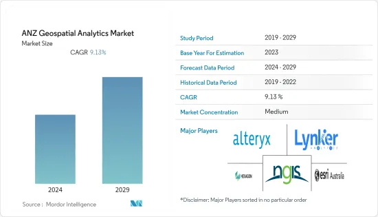
澳洲和纽西兰地理空间分析市场规模预计未来五年将从目前的 6.2 亿美元成长到 9.5 亿美元,预测期内复合年增长率为 9.13%。
澳洲和纽西兰地理空间分析市场的推动因素包括各种公共和私人最终用户行业不断增长的需求、大型市场参与企业的存在以及城市规划中对地理空间分析的需求不断增长。
主要亮点
- 澳洲和纽西兰的地理空间分析生态系统持续发展,市场参与企业看到创新地理空间分析解决方案的成长,包括人工智慧 (AI) 和机器学习 (ML),可从地理空间资料中获得有意义的见解。近年来,由于地理空间分析解决方案的出现,澳洲和纽西兰的地理空间分析生态系统经历了显着增长。以增加先进技术的使用。此外,越来越多地使用资讯资讯做出明智的决策,进一步推动了该地区对地理空间功能和地理空间分析解决方案的需求。
- 该地区的市场供应商正在利用先进技术在地理空间领域提供创新的分析功能,并对其进行进一步分析,以推动该地区最终用户行业对地理空间分析解决方案的需求。我就是。例如,总部位于澳洲的地理空间情报公司在地理空间分析、巨量资料和连结分析、机器学习、人工智慧以及有效使用者介面的开发方面拥有丰富的专业知识。这些技能使该公司能够开发复杂且创新的地理空间分析工具,这些工具可以自动从大型资料集集中提取资料和资讯,并以支持资讯决策的格式呈现这些资讯。
- 卫星和感测器等地理空间资料的可用性和可访问性的提高正在推动市场成长。因为地理空间资料可以透过利用地理空间分析解决方案为全部区域的组织提供资讯、明智的决策和有价值的见解。例如,纽西兰土地资讯(LINZ) 专注于发布纽西兰建筑和自然环境的详细地理空间资料模型。 LINZ 在 data.linz.govt.nz 上共用其资料集,从道路和河流资料到航空影像和雷射雷达。
- 此外,2023 年 5 月,Vexcel 资料计画宣布透过其基于网路的平台 Viewer 免费存取纽西兰和澳洲的航空图像。此免费存取为商业和政府用户提供主要大都市区的高解析度、高精度图像,包括珀斯、奥克兰、雪梨、墨尔本、布里斯班、惠灵顿和基督城。澳洲和纽西兰的组织可以参与这项免费服务。预计这些因素将在预测期内为该地区的地理空间分析市场提供成长机会。这些因素推动了组织对地理空间分析解决方案的需求,以从影像、卫星和感测器的空间资料中实现利润最大化和竞争优势。
- 在 COVID-19 大流行期间,该地区对地理空间分析解决方案表现出了巨大的需求,以提供对抗 COVID-19 大流行的关键资讯。 EMSINA(澳洲紧急管理空间资讯网路)等地区政府机构已与 Esri Australia 等市场供应商合作,使用地理空间资料集来对抗疫情。大流行后,由于该地区领先供应商开发的创新和复杂的地理空间分析解决方案的增加,市场出现了显着增长。
澳洲和纽西兰地理空间分析市场趋势
农业部门预计将占据较大市场占有率
- 近年来,在智慧和精密农业实践的推动下,澳洲和纽西兰地区的农业部门取得了显着成长。该地区生产和出口多种农产品,包括牛和小麦,使农业成为该地区的重要经济部门。地理空间分析解决方案具有多种优势,包括现场资料映射、组织和分析以及远端作物监测。
- 该地区的农业部门正在大量采用地理空间分析解决方案,透过整合高解析度影像、实地观察和即时资料馈送来了解如何充分利用有限的资源。 Esri Australia 等供应商正积极致力于农业领域的创新地理空间分析解决方案,进而影响市场成长。
- 此外,该地区还有许多精密农业提供者在推广精密农业实践。精密农业涉及多种技术的使用,包括 GPS、无人机、感测器和高级分析。精密农业实践预计将要求使用地理空间分析来改善农场决策和规划,并积极推动澳洲-纽西兰地区农业部门对地理空间分析的需求。
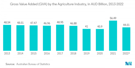
- 此外,农业对澳洲-纽西兰地区至关重要,该产业积极推动了该地区的国内生产总值。市场供应商开发的农业专用地理空间解决方案为农业产业提供了成长前景,因为该地区的农业产业采用地理空间分析解决方案,这将对市场成长产生积极影响。例如,根据澳洲统计局的资料,截至2022年9月,澳洲农业附加价值毛额(GVA)达440.1亿澳元(约289.2亿美元)。
澳洲预计将出现显着成长
- 由于从农业到城市规划等终端用户行业的需求不断增长,预计澳洲在未来几年将大量采用地理空间分析解决方案。此外,该国拥有着名的市场供应商,他们不断为不同行业创新地理空间分析产品,对该国的市场成长产生了积极影响。
- 例如,Experian Australia 为国内零售业提供地理空间分析解决方案。透过地理空间分析和解决方案,该公司帮助零售商更有效地选择位置,确定收益驱动因素,更好地协调零售/分店服务、产品和消费者,以及更准确地衡量商店周转率额。好处包括更准确的估计和更好地了解竞争影响。
- 此外,中国日益增长的都市化进一步增加了对地理空间分析解决方案的需求,以实现正确有效的城市规划。例如,根据世界银行的资料,澳洲的都市化将从2005年的84.22%上升到2022年的86.49%。此外,澳洲地理资讯系统、数位分析和遥感 (GDARS) 实践领域委员会认识到地理资讯系统、数位分析和遥感在城市规划和自然资源管理、灾害应变和公共卫生等应用中发挥的重要作用。意识到我的角色。
- 此外,该国的公共产业正在与地理空间分析公司合作,解决围绕网路协调的核心资料问题,并实施预测性维护策略,以减少网路故障和损坏。例如,2022年11月,Horizon Power的地理空间情报计画将推出地理空间情报解决方案,利用遥感、影像和高级分析技术来转变公用事业公司快速了解其网路健康状况的能力。透过跨越数千公里的网络,地理资讯程序可以优化资产性能并保持网路的可靠和安全。该公用事业公司求助于地理空间专家 Altavec 来提供该程式。
澳洲和纽西兰地理空间分析产业概述
澳洲-纽西兰地理空间分析市场适度整合,少数大型供应商占了重要的市场占有率。该地区的市场参与企业正在热衷于合作和收购活动,并推出整合先进技术的新型创新地理空间分析解决方案。澳洲-纽西兰地理空间分析市场的主要市场供应商包括 NGIS Australia Pty Ltd (NGIS)、Alteryx、Hexagon AB、Esri Australia 和 Lynker Analytics Ltd。
2022 年 12 月,地理空间资料、分析和分析的专业供应商澳洲 Geospatial Intelligence Pty Ltd 宣布与全球领先的高解析度卫星影像供应商之一 Satellogic 建立新的合作伙伴关係。 Satellogic 设计、製造和营运地球观测 (EO) 卫星,以实惠的价格收集高解析度影像。该公司的四个频谱波段(蓝色、红色、绿色和近红外线)经过正射校正、GIS 就绪,并以最低 70 公分分辨率提供。
其他福利:
- Excel 格式的市场预测 (ME) 表
- 3 个月分析师支持
目录
第一章简介
- 研究假设和市场定义
- 调查范围
第二章调查方法
第三章执行摘要
第四章市场洞察
- 市场概况
- 产业吸引力-波特五力分析
- 买方议价能力
- 供应商的议价能力
- 新进入者的威胁
- 替代品的威胁
- 竞争公司之间的敌对关係
- 产业价值链分析
- COVID-19 市场影响评估
第五章市场动态
- 市场驱动因素
- 智慧城市发展和城市规划对地理空间分析的需求不断增长
- 将人工智慧和机器学习等先进技术整合到地理空间分析解决方案中
- 市场抑制因素
- 与地理空间分析解决方案相关的成本上升
第六章市场区隔
- 按类型
- 表面分析
- 网路分析
- 地理视觉化
- 按行业分类
- 农业
- 公共产业和通讯
- 国防/资讯
- 政府机关
- 采矿/自然资源
- 汽车与运输
- 医疗保健
- 房地产/建筑业
- 按行业分類的其他最终用户
- 按国家/地区
- 澳洲
- 纽西兰
第七章 竞争形势
- 公司简介
- NGIS Australia Pty Ltd(NGIS)
- Alteryx
- Hexagon AB
- Esri Australia
- Lynker Analytics Ltd
- Intermap Technologies
- Mapizy Pty Ltd.
- New Zealand Geoanalytics Ltd.
- CoreLogic NZ Limited
- Abley Ltd
- Geospatial Intelligence Pty Ltd.
第八章投资分析
第九章 市场机会及未来趋势
The ANZ geospatial analytics market size is expected to grow from USD 0.62 billion in the current year to USD 0.95 billion in the next five years at a CAGR of 9.13% during the forecast period. The ANZ geospatial analytics market is driven by the increasing demand from various public and private end-user industries, the presence of major market players, and the increasing demand for geospatial analytics in urban planning.
Key Highlights
- The ANZ geospatial analytics ecosystem has witnessed substantial growth in the past couple of years owing to the growth in innovative geospatial analytics solutions by the market players and the increasing use of advanced technologies such as artificial intelligence(AI) and machine learning(ML) for meaningful insights from the geospatial data. Moreover, the increasing use of location information to make informed decisions further drives the demand for geospatial capabilities and geospatial analytics solutions in the region.
- Market vendors in the region are using advanced technologies to offer innovative analytics capabilities in the geospatial domain, which is further analyzed to boost the demand for geospatial analytics solutions in the end-user industries across the region. For instance, Australia-based geospatial intelligence has considerable expertise in geospatial analysis, big data & link analytics, machine learning, artificial intelligence, and the development of effective user interfaces. These skills allow the company to develop sophisticated and innovative geospatial analytical tools that automate the extraction of data and information from large data sets and display this information in a format that supports informed decision-making.
- The increasing availability and accessibility of geospatial data from satellites, sensors, etc., aided the market's growth, as the geospatial data can provide substantial informed decisions and valuable insights by leveraging geospatial analytics solutions in organizations across the region. For instance, the National mapping agency Land Information New Zealand (LINZ) focused on publishing detailed geospatial data that models New Zealand's built and natural environments. LINZ shares its datasets-from road and river data to aerial imagery and LiDAR-on data.linz.govt.nz.
- Further, in May 2023, Vexcel Data Program announced free access to aerial imagery in New Zealand and Australia through its web-based platform, Viewer. This no-cost access provides commercial and government users with high-resolution, highly accurate imagery of major metro areas such as Perth, Auckland, Sydney, Melbourne, Brisbane, Wellington, and Christchurch. Australian and New Zealand organizations are eligible to participate in this free offering. Such factors are further expected to offer growth opportunities for the geospatial analytics market in the region over the forecast period. Such factors have driven organizations' demand for geospatial analytics solutions to maximize benefits and competitive edge from the spatial data from imagery, satellites, and sensors.
- During the COVID-19 pandemic, Geospatial Analytics Solutions witnessed substantial demand to offer Vital Information for Combating COVID-19 Pandemic in the region. Government organizations in the region, such as Emergency Management Spatial Information Network Australia (EMSINA), partnered with market vendors such as Esri Australia to combat the pandemic using geospatial datasets. Post-pandemic, the market is witnessing substantial growth owing to the increase in innovative and sophisticated geospatial analytics solutions developed by the major market vendors in the region.
ANZ Geospatial Analytics Market Trends
Agriculture Segment is Anticipated to Hold Significant Market Share
- The ANZ region's agriculture sector has grown substantially in the past few years, led by smart farming and precision agriculture practices. The region produces and exports a diverse range of agricultural products, including cattle, and wheat, making agriculture an important economic sector of the region. Various benefits are associated with geospatial analytics solutions, such as mapping field data, organizing and analyzing it, and monitoring their crops remotely.
- The agriculture sector in the region is witnessing substantial adoption of geospatial analytics solutions by integrating high-resolution imagery, field observations, and real-time data feeds to understand how to make the most of limited resources. Market vendors such as Esri Australia are actively innovating geospatial analytics solutions in the agriculture domain, thus impacting the growth of the market.
- Further, the region is promoting precision agriculture practices with the presence of many precision agriculture providers. Precision agriculture involves the use of various technologies, such as GPS, drones, sensors, and advanced analytics. Precision agriculture practices are expected to seek the use of geospatial analytics to improve farm decision-making and planning, thus positively driving the demand for geospatial analytics in the agriculture sector of the ANZ region.
- Additionally, agriculture is becoming vital in the ANZ region, with the industry actively driving the region's GDP. The agriculture industry's adoption of geospatial analytics solutions in the region owing to the agriculture sector-specific geospatial solutions developed by market vendors are further analyzed to offer growth prospects to the agriculture industry, thus positively impacting the growth of the market. For instance, according to the Australian Bureau of Statistics data, as of September 2022, the gross value added (GVA) of the agriculture industry in Australia reached AUD 44.01 billion (~USD 28.92 billion).
Australia is Expected to Witness Substantial Growth
- Australia is expected to witness substantial adoption of geospatial analytics solutions in the coming years owing to the growing demand from various end-user industries ranging from agriculture to urban planning. Moreover, the country is home to some of the prominent market vendors who are continuously innovating their geospatial analytics offerings for a diverse range of industries, thus positively impacting the market growth in the country.
- For instance, Experian Australia offers geospatial analytics solutions for the retail sector in the country. The company provides benefits for retail organizations through its geospatial analytics solutions, such as more effective site selection, identification of profitability drivers, better alignment between retail/branch services, products, and consumers, more accurate estimates of store turnover, and improved understanding of competitor impact.
- Moreover, the high degree of urbanization in the country is further driving the demand for geospatial analytics solutions for proper and effective urban planning. For instance, according to the data from the World Bank, urbanization in Australia increased from 84.22% in 2005 to 86.49% in 2022. Further, the GIS, Digital Analytics, and Remote Sensing (GDARS) Area of Practice Committee in Australia recognizes the critical role that GIS, digital analytics, and remote sensing play in various applications, from urban planning and natural resource management to disaster response and public health.
- Further, utility companies in the country are partnering with geospatial analytics companies to deal with core data issues with network alignment and implement predictive maintenance strategies to reduce network failures and damages. For instance, in November 2022, Horizon Power's Geospatial Intelligence Program leveraged remote sensing, imagery, and advanced analytic technologies to deliver a geospatial intelligence solution that transforms the utility's ability to understand the state of the network quickly. With a network spanning thousands of kilometers, the geospatial intelligence program will optimize asset performance and keep the network reliable and safe. The utility company has selected geospatial specialist Altavec to deliver the program.
ANZ Geospatial Analytics Industry Overview
The ANZ geospatial analytics market is moderately consolidated owing to a few major market vendors holding significant market share. The market players in the region are indulging in partnership and acquisition activities and launching new innovative geospatial analytics solutions with the integration of advanced technologies. A few major market vendors in the ANZ geospatial analytics market include NGIS Australia Pty Ltd (NGIS), Alteryx, Hexagon AB, Esri Australia, and Lynker Analytics Ltd, among others.
In December 2022, Australia-based Geospatial Intelligence Pty Ltd, a specialist geospatial data, analysis, and analytics provider, announced a new partnership with Satellogic, one of the leading global providers of high-resolution satellite imagery. Satellogic designs, builds, and operates its fleet of earth observation (EO) satellites to collect affordable, high-resolution imagery. Its four multispectral bands (blue, red, green, near-IR) are delivered ortho-rectified and GIS-ready, available at 70 cm resolution on nadir.
Additional Benefits:
- The market estimate (ME) sheet in Excel format
- 3 months of analyst support
TABLE OF CONTENTS
1 INTRODUCTION
- 1.1 Study Assumptions and Market Definition
- 1.2 Scope of the Study
2 RESEARCH METHODOLOGY
3 EXECUTIVE SUMMARY
4 MARKET INSIGHTS
- 4.1 Market Overview
- 4.2 Industry Attractiveness - Porter's Five Forces Analysis
- 4.2.1 Bargaining Power of Buyers
- 4.2.2 Bargaining Power of Suppliers
- 4.2.3 Threat of New Entrants
- 4.2.4 Threat of Substitutes
- 4.2.5 Intensity of Competitive Rivalry
- 4.3 Industry Value Chain Analysis
- 4.4 Assessment of the Impact of COVID-19 on the Market
5 MARKET DYNAMICS
- 5.1 Market Drivers
- 5.1.1 Growing Demand for Geospatial Analytics in Smart City Development and Urban Planning
- 5.1.2 Integration of Advanced Technologies such as AI and ML in Geospatial Analytics Solutions
- 5.2 Market Restraints
- 5.2.1 Higher Costs Associated With Geospatial Analytics Solutions
6 MARKET SEGMENTATION
- 6.1 By Type
- 6.1.1 Surface Analysis
- 6.1.2 Network Analysis
- 6.1.3 Geovisualization
- 6.2 By End-user Vertical
- 6.2.1 Agriculture
- 6.2.2 Utility and Communication
- 6.2.3 Defense and Intelligence
- 6.2.4 Government
- 6.2.5 Mining and Natural Resources
- 6.2.6 Automotive and Transportation
- 6.2.7 Healthcare
- 6.2.8 Real Estate and Construction
- 6.2.9 Other End-user Verticals
- 6.3 By Country
- 6.3.1 Australia
- 6.3.2 New Zealand
7 COMPETITIVE LANDSCAPE
- 7.1 Company Profiles
- 7.1.1 NGIS Australia Pty Ltd (NGIS)
- 7.1.2 Alteryx
- 7.1.3 Hexagon AB
- 7.1.4 Esri Australia
- 7.1.5 Lynker Analytics Ltd
- 7.1.6 Intermap Technologies
- 7.1.7 Mapizy Pty Ltd.
- 7.1.8 New Zealand Geoanalytics Ltd.
- 7.1.9 CoreLogic NZ Limited
- 7.1.10 Abley Ltd
- 7.1.11 Geospatial Intelligence Pty Ltd.
8 INVESTMENT ANALYSIS
9 MARKET OPPORTUNITIES AND FUTURE TRENDS
 地理空间分析 -市场占有率分析、产业趋势与统计、成长预测(2025-2030)
 2025年全球地理空间分析AI市场报告2025年地理空间分析全球市场报告
 全球地理空间分析市场:按产品、技术、资料类型、产业、地区划分 - 到 2029 年的预测
 地理空间分析市场规模、份额、成长分析,按产品、按技术、按行业、按地区 - 按行业预测,2024-2031 年
 全球地理空间分析市场按组件、部署模式、组织规模、类型和垂直划分 - 机会分析和行业预测,2024 年至 2033 年
 地理空间分析市场:按类型、组件、应用、产业划分 - 2025-2030 年全球预测汽车地理空间分析市场:按组件、技术、应用、车辆类型和最终用户划分 - 2025-2030 年全球预测2024-2032 年按组件、类型、技术、企业规模、部署模式、垂直产业和区域分類的地理空间分析市场报告日本地理空间分析:市场占有率分析、产业趋势与统计、成长预测(2024-2029)