


 |
市场调查报告书
商品编码
1939750
数位地图:市场占有率分析、产业趋势与统计、成长预测(2026-2031)Digital Map - Market Share Analysis, Industry Trends & Statistics, Growth Forecasts (2026 - 2031) |
||||||
※ 本网页内容可能与最新版本有所差异。详细情况请与我们联繫。
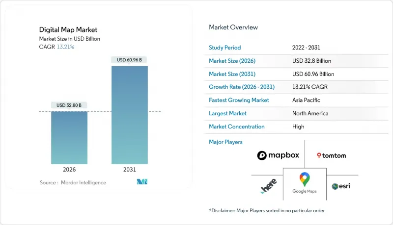
据估计,到 2026 年,数位地图市场价值将达到 328 亿美元,高于 2025 年的 289.7 亿美元,预计到 2031 年将达到 609.6 亿美元。
预计2026年至2031年年复合成长率(CAGR)为13.21%。
这项成长的驱动力在于向人工智慧驱动的云端原生平台转型,这些平台支撑着自动驾驶汽车、智慧城市数位双胞胎和即时地理资讯系统。欧盟的eCall和企业范围3碳排放测绘规则等法规要求,也推动了人工智慧在传统导航之外的应用。
全球数位地图市场趋势与洞察
高清地图在ADAS和自动驾驶车辆中的快速应用
BMW于2024年推出了德国首个L3级自动驾驶系统。该系统使用HERE高清即时地图,在定位、路线规划和运行设计域检验实现了车道级精度(误差在17厘米以内)。 HERE的高精度地图覆盖范围目前支援5300万辆车,比2023年增长了40%,这表明汽车製造商对承包高精度数据的依赖。 TomTom的Orbis Maps 3D覆盖了8,600万公里的道路,并整合了基于车道的导航和电动车充电层。日本的动态地图平台在2025年获得了政府支持,将高清地图扩展到机场和港口,目标是L4级自动驾驶卡车。基于人工智慧的特征提取降低了更新成本并缩短了地图製作週期,使能够近乎即时更新网路的供应商获得了竞争优势。
联网汽车的OTA地图更新生态系统快速发展
联网汽车正在将地图更新从静态授权转向持续的空中下载 (OTA) 服务。哈曼的 Smart Delta技术可将地图更新檔案压缩高达 97%,在降低资料传输成本的同时,确保软体定义车辆的安全性。为响应欧盟通用安全法规,全球十分之九的汽车製造商已采用 HERE 的智慧速度辅助地图,为其车队创建了标准化的空中下载 (OTA) 更新路径。梅赛德斯-奔驰将在 2025 年 1 月的 OTA 更新中整合电动智慧和越野追踪功能,展示地图数据如何帮助售后功能变现。
以公分为单位不断更新地图的成本增加
随着都市区建设和交通状况日益严峻,车道级地图更新需求带来了巨大的营运成本。 TomTom目前正在融合包括卫星数据、光达和行车记录器在内的多感测器数据,以实现特征提取自动化并缩短测绘週期。 GetNexar的AI视觉影像透过众包行车记录器影片降低了地图製作成本,但其所需的资金对小型供应商而言仍然难以承受。成本压力促使各厂商寻求合作和选择性外包,以在不牺牲地图精度的前提下维持更新频率。
细分市场分析
到2025年,软体解决方案将占据数位地图市场60.85%的份额,这反映出企业对可配置、API驱动且整合跨职能空间分析的平台的需求。功能丰富的SDK使开发人员能够将地图、路线导航和地理编码功能嵌入到出行、物流和零售应用程式中。业务收益正以13.28%的复合年增长率成长,这反映出随着企业将传统GIS迁移到云端环境,并需要託管整合、资料品质协调和用户支援计划,业务复杂性日益增加。现代平台中的AI模组可自动进行铁路标誌检测、标誌识别和资产状况评估,从而提高营运效率。
对专业服务日益增长的需求也反映出合规要求,即必须对位置资料管道进行专家审核。文件工具、授权管理工具和地理围篱策略引擎正被纳入实施计划中,以确保跨境部署的合法性。随着企业资料量的成长,供应商营运的託管服务越来越多地承担资料撷取、标准化和近即时串流处理的工作,从而确保除一次性许可费之外的持续收入。
预计到2025年,云端部署将占数位地图市场规模的65.10%,并在2031年之前以15.55%的复合年增长率成长。弹性运算和储存可确保每天数十亿次路线请求的亚秒级查询效能。自动扩展功能可应对恶劣天气和假日期间的交通高峰。边缘采集节点将最新的探测资料传送到集中式储存库,从而确保为叫车、物流和紧急应变提供最新的地图资料。
在国防、航空和监管严格的金融领域,本地部署仍在继续,但随着主权云端区域、专用託管选项和机密运算飞地的普及,安全疑虑有所缓解,本地部署正在减少。成本模式正从计量收费支出 (CapEx) 转向按需付费的营运支出 (OpEx),从而释放资金用于人工智慧实验和跨域资料整合。企业越来越倾向于将地图绘製视为更广泛的资料平台策略中的微服务,而不是独立的地理资讯系统 (GIS) 功能。
数位地图市场按解决方案(软体、服务)、部署模式(本地部署、云端部署)、地图类型(导航地图、高清即时地图、地形图和专题地图)、最终用户产业(汽车、工程建设、电信等)以及地区进行细分。市场预测以美元以金额为准。
区域分析
到2025年,北美将占据数位地图市场29.10%的份额,这主要得益于软体定义车辆、云端地理资讯系统(GIS)和国防地理空间专案的早期应用。联邦机构正在积极推动开放空间框架的构建,而汽车製造商则持续投入大量研发力量用于自动化。大型基础设施计划正在采用数位地形模型(DTM)和全球导航卫星系统(GNSS)机器控制技术,以缩短施工週期并提高资产全生命週期的可视性。数据货币化主导,例如车队远端资讯处理服务提供商,正在持续提供匿名化的探测数据,这对于维护区域地图的精确度至关重要。
亚太地区将在2031年前维持15.22%的最高复合年增长率,主要得益于5G用户成长、智慧运输资金投入以及政府主导的数位双胞胎计画。日本企业正在收集高精度道路数据,用于卡车编队行驶和都市区无人出租车演示,从而加速了对精准测绘的需求。中国云端服务供应商正在提供高容量位置API以支援电子商务物流,而印度的5G网路正在推动公共产业和农业领域的地理资讯系统(GIS)现代化。对区域超大规模资料中心的投资也将有助于应对资料主权法规,使全球供应商能够透过国内终端服务本地客户。
其他福利:
- Excel格式的市场预测(ME)表
- 分析师支持(3个月)
目录
第一章 引言
- 研究假设和市场定义
- 调查范围
第二章调查方法
第三章执行摘要
第四章 市场情势
- 市场概览
- 市场驱动因素
- 快速采用高解析度地图进行进阶驾驶辅助系统和自动驾驶汽车应用
- 联网汽车OTA地图更新生态系的爆炸性成长
- 云端原生GIS平台成为主流
- 全球智慧城市数位双胞胎计画发展
- 欧盟电子呼叫强制令及下一代道路安全法规
- 企业范围 3 碳排放测绘要求
- 市场限制
- 以公分为单位不断更新地图的成本增加
- 加强资料隐私和在地化法律(GDPR、PIPL)
- 数据提供者与原始设备製造商之间的知识产权许可纠纷
- 人工智慧生成地图中的演算法偏见与责任问题
- 价值/供应链分析
- 监管环境
- 技术展望
- 波特五力模型
- 新进入者的威胁
- 买方的议价能力
- 供应商的议价能力
- 替代品的威胁
- 竞争对手之间的竞争
第五章 市场规模与成长预测
- 透过解决方案
- 软体
- 服务
- 透过部署
- 本地部署
- 云
- 按地图类型
- 导航地图
- 高清即时地图
- 地形图和专题地图
- 按最终用途行业划分
- 车
- 工程与施工
- 沟通
- 公共部门和国防部门
- 零售和地理行销
- 其他最终用户
- 按地区
- 北美洲
- 我们
- 加拿大
- 墨西哥
- 南美洲
- 巴西
- 阿根廷
- 其他南美洲
- 欧洲
- 德国
- 英国
- 法国
- 荷兰
- 其他欧洲地区
- 亚太地区
- 中国
- 日本
- 印度
- 韩国
- 澳洲和纽西兰
- 亚太其他地区
- 中东和非洲
- 中东
- 阿拉伯聯合大公国
- 沙乌地阿拉伯
- 土耳其
- 其他中东地区
- 非洲
- 南非
- 奈及利亚
- 其他非洲地区
- 中东
- 北美洲
第六章 竞争情势
- 市场集中度
- 策略趋势
- 市占率分析
- 公司简介
- Alphabet(Google Maps, Waze)
- HERE Technologies
- TomTom International BV
- Esri
- Mapbox
- Apple Inc.(Apple Maps)
- Maxar Technologies(DigitalGlobe)
- Collins Bartholomew
- Digital Map Products
- Digital Mapping Solutions
- DMTI Spatial
- Lepton Software
- ThinkGeo
- MapData Services
- NavInfo Co. Ltd.
- AutoNavi(Gaode, Alibaba)
- Baidu Maps
- Nearmap Ltd
- Zenrin Co. Ltd.
- Trimble Inc.
- CARTO
- OpenStreetMap Foundation
- MapQuest(Verizon)
第七章 市场机会与未来展望
The digital map market size in 2026 is estimated at USD 32.8 billion, growing from 2025 value of USD 28.97 billion with 2031 projections showing USD 60.96 billion, growing at 13.21% CAGR over 2026-2031.
Growth stems from the transition toward AI-powered, cloud-native platforms that support autonomous vehicles, smart-city digital twins, and real-time geographic information systems. Regulatory mandates such as EU eCall and emerging corporate Scope 3 carbon-mapping rules broaden adoption beyond conventional navigation.
Global Digital Map Market Trends and Insights
Rapid Uptake of HD Maps for ADAS and Autonomous Vehicles
BMW launched Germany's first Level 3 system in 2024 using HERE HD Live Map that delivers lane-level accuracy within 17 cm for localization, path planning, and operational-design-domain validation. HERE's high-precision coverage now supports 53 million vehicles, a 40% rise over 2023, indicating OEM reliance on turnkey HD data. TomTom's Orbis Maps 3D spans 86 million km of roads and integrates lane-based navigation with electric-vehicle charging layers. Japan's Dynamic Map Platform received government backing in 2025 to expand HD maps to airports and ports, targeting Level 4 autonomous trucks. AI-based feature extraction lowers refresh costs and shortens map-creation cycles, delivering competitive advantage to providers able to update networks in near-real time.
Explosive Growth of Connected-Car OTA Map-Update Ecosystems
Connected vehicles are shifting maps from static licenses to recurring over-the-air services. HARMAN's Smart Delta technology compresses map-update files by up to 97%, cutting data-transfer costs while maintaining software-defined-vehicle safety integrity. Nine of ten global OEMs deploy HERE's Intelligent Speed Assistance Map to address EU General Safety Regulation compliance, creating standardized OTA pathways for fleet-wide updates. Mercedes-Benz integrated electric-intelligence and off-road tracking features via its January 2025 OTA release, illustrating how map data enables post-sale feature monetization.
Escalating Costs of Continuous, Centimeter-Level Map Refresh
Lane-level refresh requirements drive substantial operational costs as construction and traffic changes intensify in urban zones. TomTom now fuses multi-sensor data-satellite, LiDAR, onboard cameras-to automate feature extraction and cut survey cycles. GetNexar's AI vision reduces cartography expense by crowd-sourcing dash-cam imagery, yet capital requirements remain onerous for smaller vendors. Cost pressures encourage alliances and selective outsourcing to maintain update cadence without sacrificing map accuracy.
Other drivers and restraints analyzed in the detailed report include:
- Mainstream Adoption of Cloud-Native GIS Platforms
- Smart-City Digital-Twin Programs Scaling Globally
- Heightened Data-Privacy and Localization Statutes (GDPR, PIPL)
For complete list of drivers and restraints, kindly check the Table Of Contents.
Segment Analysis
Software solutions captured 60.85% of the digital map market in 2025, reflecting enterprise demand for configurable, API-driven platforms that consolidate spatial analytics across departments. Feature-rich SDKs allow developers to embed maps, routing, and geocoding into mobility, logistics, and retail applications. Services revenue, growing at 13.28% CAGR, mirrors rising complexity as organizations migrate legacy GIS to cloud environments and seek managed integration, data-quality tuning, and user-enablement programs. AI modules within modern platforms automate line-mark detection, sign recognition, and asset-condition scoring, catalyzing operational efficiencies.
Professional-services uptake also reflects compliance mandates that require expert audits of location-data pipelines. Documentation, consent-management tools, and geo-fencing policy engines are bundled into implementation projects to ensure lawful deployment across borders. As enterprise data volumes scale, vendor-operated managed services increasingly handle ingestion, normalization, and near-real-time streaming, locking in recurring revenue beyond one-time license fees.
Cloud deployment held 65.10% share of the digital map market size in 2025 and is forecast to expand at 15.55% CAGR through 2031. Elastic compute and storage enable sub-second query performance for billions of daily route requests while auto-scaling manages traffic peaks during severe-weather or holiday seasons. Edge ingestion nodes push fresh probe data into centralized repositories, ensuring map freshness for ride-hailing, logistics, and emergency response.
On-premise installations persist in defense, aviation, and highly regulated finance but trend downward as sovereign-cloud regions, dedicated host options, and confidential-computing enclaves mitigate security objections. Cost models shift from capex to pay-as-you-go opex, freeing capital for AI experimentation and cross-domain data fusion. Enterprises increasingly view mapping as a micro-service consumed within broader data-platform strategies rather than a standalone GIS function.
Digital Map Market is Segmented by Solution (Software, Services), Deployment (On-Premise, Cloud), Map Type (Navigation Maps, HD and Real-Time Maps, Topographic and Thematic Maps), End User Industry (Automotive, Engineering and Construction, Telecommunications and More), and by Geography. The Market Forecasts are Provided in Terms of Value (USD).
Geography Analysis
North America accounted for 29.10% digital map market share in 2025, anchored by early adoption of software-defined vehicles, cloud GIS, and defense geospatial programs. Federal agencies promote open spatial frameworks, and automotive OEMs maintain deep research pipelines for automation. Large-scale infrastructure projects employ digital terrain models and GNSS machine-control to shorten build cycles and enhance asset lifecycle visibility. Data-monetization champions such as fleet telematics providers continuously feed anonymized probe data that sustain regional map accuracy.
Asia-Pacific delivers the highest 15.22% CAGR through 2031, powered by 5G subscriber growth, smart-mobility funding, and government-backed digital-twin mandates. Japan's industry collects HD corridor data for truck platooning and metropolitan robo-taxi pilots, accelerating HD mapping demand. China's cloud providers expose high-volume location APIs to power e-commerce logistics, while India's 5G networks stimulate GIS modernization across utilities and agriculture. Investments in regional hyperscale data centers also address data-sovereignty rules, enabling global vendors to serve local customers via in-country endpoints.
- Alphabet (Google Maps, Waze)
- HERE Technologies
- TomTom International B.V.
- Esri
- Mapbox
- Apple Inc. (Apple Maps)
- Maxar Technologies (DigitalGlobe)
- Collins Bartholomew
- Digital Map Products
- Digital Mapping Solutions
- DMTI Spatial
- Lepton Software
- ThinkGeo
- MapData Services
- NavInfo Co. Ltd.
- AutoNavi (Gaode, Alibaba)
- Baidu Maps
- Nearmap Ltd
- Zenrin Co. Ltd.
- Trimble Inc.
- CARTO
- OpenStreetMap Foundation
- MapQuest (Verizon)
Additional Benefits:
- The market estimate (ME) sheet in Excel format
- 3 months of analyst support
TABLE OF CONTENTS
1 INTRODUCTION
- 1.1 Study Assumptions and Market Definition
- 1.2 Scope of the Study
2 RESEARCH METHODOLOGY
3 EXECUTIVE SUMMARY
4 MARKET LANDSCAPE
- 4.1 Market Overview
- 4.2 Market Drivers
- 4.2.1 Rapid uptake of HD maps for ADAS and autonomous vehicles
- 4.2.2 Explosive growth of connected-car OTA map-update ecosystems
- 4.2.3 Mainstream adoption of cloud-native GIS platforms
- 4.2.4 Smart-city digital-twin programs scaling globally
- 4.2.5 Mandatory EU eCall and next-gen road-safety regulations
- 4.2.6 Corporate Scope-3 carbon mapping requirements
- 4.3 Market Restraints
- 4.3.1 Escalating costs of continuous, centimetre-level map refresh
- 4.3.2 Heightened data-privacy and localization statutes (GDPR, PIPL)
- 4.3.3 IP-licensing disputes among data providers and OEMs
- 4.3.4 Algorithmic bias and liability concerns in AI-generated maps
- 4.4 Value / Supply-Chain Analysis
- 4.5 Regulatory Landscape
- 4.6 Technological Outlook
- 4.7 Porter's Five Forces
- 4.7.1 Threat of New Entrants
- 4.7.2 Bargaining Power of Buyers
- 4.7.3 Bargaining Power of Suppliers
- 4.7.4 Threat of Substitutes
- 4.7.5 Intensity of Competitive Rivalry
5 MARKET SIZE AND GROWTH FORECASTS (VALUE)
- 5.1 By Solution
- 5.1.1 Software
- 5.1.2 Services
- 5.2 By Deployment
- 5.2.1 On-Premise
- 5.2.2 Cloud
- 5.3 By Map Type
- 5.3.1 Navigation Maps
- 5.3.2 HD and Real-time Maps
- 5.3.3 Topographic and Thematic Maps
- 5.4 By End-use Industry
- 5.4.1 Automotive
- 5.4.2 Engineering and Construction
- 5.4.3 Telecommunications
- 5.4.4 Public Sector and Defense
- 5.4.5 Retail and Geomarketing
- 5.4.6 Other End User
- 5.5 By Geography
- 5.5.1 North America
- 5.5.1.1 United States
- 5.5.1.2 Canada
- 5.5.1.3 Mexico
- 5.5.2 South America
- 5.5.2.1 Brazil
- 5.5.2.2 Argentina
- 5.5.2.3 Rest of South America
- 5.5.3 Europe
- 5.5.3.1 Germany
- 5.5.3.2 United Kingdom
- 5.5.3.3 France
- 5.5.3.4 Netherlands
- 5.5.3.5 Rest of Europe
- 5.5.4 Asia-Pacific
- 5.5.4.1 China
- 5.5.4.2 Japan
- 5.5.4.3 India
- 5.5.4.4 South Korea
- 5.5.4.5 Australia and New Zealand
- 5.5.4.6 Rest of Asia-Pacific
- 5.5.5 Middle East and Africa
- 5.5.5.1 Middle East
- 5.5.5.1.1 United Arab Emirates
- 5.5.5.1.2 Saudi Arabia
- 5.5.5.1.3 Turkey
- 5.5.5.1.4 Rest of Middle East
- 5.5.5.2 Africa
- 5.5.5.2.1 South Africa
- 5.5.5.2.2 Nigeria
- 5.5.5.2.3 Rest of Africa
- 5.5.5.1 Middle East
- 5.5.1 North America
6 COMPETITIVE LANDSCAPE
- 6.1 Market Concentration
- 6.2 Strategic Moves
- 6.3 Market Share Analysis
- 6.4 Company Profiles (includes Global level Overview, Market level overview, Core Segments, Financials as available, Strategic Information, Market Rank/Share for key companies, Products and Services, and Recent Developments)
- 6.4.1 Alphabet (Google Maps, Waze)
- 6.4.2 HERE Technologies
- 6.4.3 TomTom International B.V.
- 6.4.4 Esri
- 6.4.5 Mapbox
- 6.4.6 Apple Inc. (Apple Maps)
- 6.4.7 Maxar Technologies (DigitalGlobe)
- 6.4.8 Collins Bartholomew
- 6.4.9 Digital Map Products
- 6.4.10 Digital Mapping Solutions
- 6.4.11 DMTI Spatial
- 6.4.12 Lepton Software
- 6.4.13 ThinkGeo
- 6.4.14 MapData Services
- 6.4.15 NavInfo Co. Ltd.
- 6.4.16 AutoNavi (Gaode, Alibaba)
- 6.4.17 Baidu Maps
- 6.4.18 Nearmap Ltd
- 6.4.19 Zenrin Co. Ltd.
- 6.4.20 Trimble Inc.
- 6.4.21 CARTO
- 6.4.22 OpenStreetMap Foundation
- 6.4.23 MapQuest (Verizon)
7 MARKET OPPORTUNITIES AND FUTURE OUTLOOK
- 7.1 White-space and Unmet-need Assessment
 数位地图市场分析及预测(至2035年):类型、产品类型、服务、技术、组件、应用、部署模式、最终用户
 2026年全球数位地图市场报告
 全球数位地图市场规模、份额、趋势和成长分析报告(2026-2034)
 数位地图市场-全球产业规模、份额、趋势、机会及预测(按组件、部署类型、技术、应用、最终用户、地区和竞争格局划分),2021-2031年
 网路视觉化软体市场:按公司规模、解决方案类型、组件、部署模式、应用和行业垂直领域划分 - 全球预测(2026-2032 年)
 全球数位地图市场(按解决方案和用例)预测(至 2030 年)
 2025-2029年全球数位地图市场
 数位地图市场:各零件,各部署模式,各用途,各业界,各地区,机会,预测,2017年~2031年
 数位地图市场规模、份额、成长分析、按产品、按地图类型、按用途、按规模、按地区 - 行业预测,2024-2031 年全球数位地图市场规模:地区、范围和预测