


 |
市场调查报告书
商品编码
1807085
全球 LiDAR 市场(按技术、地点、类型、范围、服务、最终用途和地区划分)- 预测至 2030 年LiDAR Market by Installation (Airborne, Ground-based), Type (Mechanical, Solid-state), Range (Short, Medium, Long), Service (Aerial Surveying, Asset Management, GIS Services, Ground-based Surveying), Region - Global Forecast to 2030 |
||||||
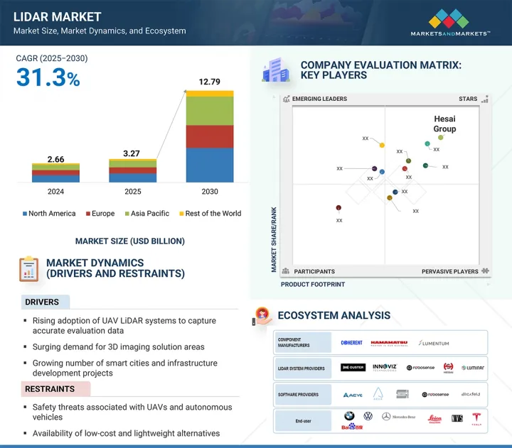
预计 LiDAR 市场规模将从 2025 年的 32.7 亿美元成长至 2030 年的 127.9 亿美元,预测期内的复合年增长率为 31.3%。
| 调查范围 | |
|---|---|
| 调查年份 | 2021-2030 |
| 基准年 | 2024 |
| 预测期 | 2025-2030 |
| 对价单位 | 金额(十亿美元) |
| 按细分市场 | 按技术、位置、类型、距离、服务、最终用途和地区 |
| 目标区域 | 北美、欧洲、亚太地区及其他地区 |
自动驾驶汽车的广泛应用推动了雷射雷达市场的发展,增加了对高精度3D测绘的需求,并增加了对智慧城市和基础设施开发计划的投资。固态雷射雷达技术的进步,以其经济高效和耐用性,进一步加速了其在汽车、环境和工业应用领域的普及。此外,政府支持数位地图和智慧交通系统的措施也推动了市场成长。然而,雷射雷达系统的高初始成本以及替代感测技术(如基于摄影机和雷达的系统)的可用性是主要阻碍因素。自主导航的标准化有限和监管挑战也阻碍了大规模部署。
预计 LiDAR 市场中的 GIS 服务部分将在预测期内以最高的复合年增长率增长,这得益于其在将原始 LiDAR 数据转化为可操作的地理空间洞察方面发挥的关键作用。交通运输、城市发展和环境监测等领域对精确製图、空间分析和基础设施规划的需求不断增长,这推动了相关应用的普及。将 LiDAR 与先进的 GIS 平台结合,可实现即时决策,提高灾害管理、农业和公共资产管理等领域的效率。政府和私人组织越来越多地投资基于 GIS 的 LiDAR 解决方案,用于智慧城市计划和基础设施现代化。此外,云端基础的GIS 和人工智慧主导的空间分析的进步正在扩展这些服务的可存取性和可扩展性。技术创新和广泛的跨行业适用性的强大组合,使 GIS 服务成为 LiDAR 市场中成长最快的部分。
地面安装的雷射雷达预计将占据最大的市场占有率,因为它广泛应用于走廊测绘、建筑、采矿、林业和环境监测等应用。它能够捕获高精度、高密度点云数据,并适用于短距离到中距离扫描,这使其成为详细地形和结构分析的理想选择。该技术广泛应用于城市规划、考古和基础设施检查中的测绘,这些领域的准确性至关重要。此外,对于中小型计划,地面雷射雷达系统比机载系统更具成本效益。建筑资讯模型 (BIM) 和工业厂房维护对地面雷射扫描的需求不断增长,进一步增强了其市场主导地位。便携性、自动化和与 GIS 平台整合方面的不断进步正在加强其在多个领域的应用。
预计北美将占据 LiDAR 市场的最大份额,这得益于该地区主要 LiDAR 製造商、技术提供商和自动驾驶汽车开发商的强大影响力。对自动驾驶汽车研究、智慧基础设施计划和先进地图计划的大量投资正在推动需求。该地区受益于政府对环境监测、国防应用和交通安全计画的大力支持。采矿、林业、建筑、石油和天然气等领域对 LiDAR 的广泛采用进一步加强了市场成长。此外,LiDAR 与人工智慧、物联网和云端基础平台的早期整合正在增强其适用性。技术领先地位、高额研发支出和多样化的最终用途采用相结合,使北美成为全球主导的 LiDAR 市场。
本报告研究了全球雷射雷达市场,并提供了按技术、位置、类型、距离、服务、最终用途和地区分類的趋势信息,以及参与市场的公司概况。
目录
第一章 引言
第二章调查方法
第三章执行摘要
第四章重要考察
第五章市场概述
- 介绍
- 市场动态
- 价值链分析
- 生态系/市场地图
- 定价分析
- 影响客户业务的趋势/中断
- 技术分析
- 波特五力分析
- 案例研究分析
- 投资金筹措场景
- 关税和监管状况
- 贸易分析
- 专利分析
- 2025-2026年主要会议和活动
- 关键相关人员和购买流程
- 人工智慧将如何影响光达市场
- 川普关税对光达市场的影响
- 主要关税税率
- 价格影响分析
- 对各地区的影响
- 对最终用途产业层面的影响
第六章 LiDAR 市场(依技术)
- 介绍
- 2D
- 3D
- 4D
第七章 雷射雷达市场(依安装地点)
- 介绍
- 空气
- 地面以上
第 8 章 LiDAR 市场(按类型)
- 介绍
- 机器
- 固态
第九章 LiDAR 市场(按距离)
- 介绍
- 短距离(0-200公尺)
- 中距离(200-500公尺)
- 远距(超过500公尺)
第十章 光达市场(按服务)
- 介绍
- 航测
- 资产管理
- 地理资讯系统(GIS)服务
- 地面勘测
- 其他的
第 11 章 光达市场(最终用途)
- 介绍
- 走廊地图
- 工程
- 环境
- ADAS 和自动驾驶汽车
- 远征
- 都市计画
- 製图
- 气象
- 其他的
第十二章 LiDAR 市场(按地区)
- 介绍
- 北美洲
- 北美宏观经济展望
- 美国
- 加拿大
- 墨西哥
- 欧洲
- 欧洲宏观经济展望
- 英国
- 德国
- 法国
- 义大利
- 西班牙
- 波兰
- 北欧的
- 其他的
- 亚太地区
- 亚太宏观经济展望
- 中国
- 日本
- 韩国
- 印度
- 澳洲
- 印尼
- 马来西亚
- 泰国
- 越南
- 其他的
- 其他地区
- 宏观经济前景持续
- 南美洲
- 中东
- 非洲
第十三章竞争格局
- 概述
- 主要参与企业的策略/优势
- 2021-2024年收益分析
- 2024年市场占有率分析
- 估值和财务指标
- 品牌/产品比较
- 公司估值矩阵:2024 年关键参与企业
- 公司估值矩阵:Start-Ups/中小企业,2024 年
- 竞争场景
第十四章:公司简介
- 主要参与企业
- ROBOSENSE
- HESAI GROUP
- LUMINAR TECHNOLOGIES, INC.
- OUSTER, INC.
- SICK AG
- LEICA GEOSYSTEMS AG
- TRIMBLE INC.
- TELEDYNE OPTECH
- FARO
- RIEGL LASER MEASUREMENT SYSTEMS GMBH
- NV5 GEOSPATIA
- SURESTAR
- YELLOWSCAN
- 其他公司
- PREACT TECHNOLOGIES
- OPSYS TECHNOLOGIES
- GEOKNO
- PHOENIX LiDAR SYSTEMS
- QUANERGY SYSTEMS, INC.
- INNOVIZ TECHNOLOGIES LTD
- LEOSPHERE
- WAYMO LLC
- VALEO
- NEPTEC TECHNOLOGIES CORP.
- ZX LiDARS
- LIVOX
- ROUTESCENE
- BLICKFELD GMBH
- SABRE ADVANCED 3D SURVEYING SYSTEMS LTD
- LEISHEN INTELLIGENT SYSTEM
第十五章 附录
The LiDAR market is projected to reach USD 12.79 billion by 2030 from USD 3.27 billion in 2025, at a CAGR of 31.3% during the forecast period.
| Scope of the Report | |
|---|---|
| Years Considered for the Study | 2021-2030 |
| Base Year | 2024 |
| Forecast Period | 2025-2030 |
| Units Considered | Value (USD Billion) |
| Segments | By Installation, Type, Range, Service, End-Use Application, and Region |
| Regions covered | North America, Europe, APAC, RoW |
The rising adoption of autonomous vehicles drives the LiDAR market, growing demand for high-precision 3D mapping, and increasing investments in smart city and infrastructure development projects. Advancements in solid-state LiDAR technology, offering cost efficiency and durability, are further accelerating adoption across automotive, environmental, and industrial applications. Additionally, government initiatives that support digital mapping and intelligent transportation systems are driving market growth. However, the high initial cost of LiDAR systems and the availability of alternative sensing technologies, such as camera and radar-based systems, act as key restraints. Limited standardization and regulatory challenges in autonomous navigation also hinder large-scale deployment.
"GIS service to witness the highest growth during the forecast period."
The GIS services segment in the LiDAR market is expected to grow at the highest CAGR during the forecast period due to its critical role in transforming raw LiDAR data into actionable geospatial insights. Increasing demand for accurate mapping, spatial analysis, and infrastructure planning in sectors such as transportation, urban development, and environmental monitoring is driving adoption. The integration of LiDAR with advanced GIS platforms enables real-time decision-making, improving efficiency in disaster management, agriculture, and utility asset management. Governments and private organizations are increasingly investing in GIS-based LiDAR solutions for smart city projects and infrastructure modernization. Furthermore, advancements in cloud-based GIS and AI-driven spatial analytics are expanding the accessibility and scalability of these services. This strong combination of technological innovation and broad cross-industry applicability positions GIS services as the fastest-growing segment in the LiDAR market.
"Ground-based installation segment to dominate the market during the forecast period."
Ground-based LiDAR is expected to hold the largest market share due to its extensive use in applications such as corridor mapping, construction, mining, forestry, and environmental monitoring. Its high accuracy, ability to capture dense point clouds, and suitability for short- to medium-range scanning make it ideal for detailed terrain and structural analysis. The technology is widely adopted for surveying and mapping in urban planning, archaeology, and infrastructure inspection, where precision is critical. Additionally, ground-based LiDAR systems are cost-effective compared to airborne counterparts for small- to mid-scale projects. The growing demand for terrestrial laser scanning in building information modeling (BIM) and industrial plant maintenance further fuels market dominance. Continuous advancements in portability, automation, and integration with GIS platforms are strengthening its adoption across multiple sectors.
"North America to hold the largest share of the LiDAR market during the forecast period."
North America is expected to hold the largest share in the LiDAR market due to the strong presence of leading LiDAR manufacturers, technology providers, and autonomous vehicle developers in the region. Significant investments in self-driving car research, smart infrastructure projects, and advanced mapping initiatives are driving demand. The region benefits from robust government support for environmental monitoring, defense applications, and transportation safety programs. High adoption of LiDAR in sectors such as mining, forestry, construction, and oil & gas further strengthens market growth. Additionally, the early integration of LiDAR with AI, IoT, and cloud-based platforms enhances its application potential. The combination of technological leadership, high R&D spending, and diverse end-use adoption positions North America as the dominant LiDAR market globally.
The study contains insights from various industry experts, from component suppliers to Tier 1 companies and OEMs. The break-up of the primaries is as follows:
- By Company Type: Tier 1 - 40%, Tier 2 - 40%, and Tier 3 - 20%
- By Designation: C-level Executives - 40%, Directors - 40%, and Others - 20%
- By Region: North America - 40%, Europe - 30%, Asia Pacific - 20%, and RoW - 10%
The report profiles key LiDAR market players and their respective market ranking analyses. Prominent players profiled in this report include Hesai Group (China), RoboSense Technology Co., Ltd. (China), Sick AG (Germany), Ouster, Inc. (US), Luminar Technologies (US), Leica Geosystems AG (Sweden), Trimble Inc. (US), Teledyne Optech (Canada), FARO Technologies, Inc. (US), RIEGL Laser Measurement Systems GmbH (Austria), NV5 Geospatial (US), Beijing SureStar Technology Co., Ltd. (China), YellowScan (France) SABRE Advanced 3D Surveying Systems (Scotland), Geokno (India), Phoenix LiDAR Systems (US), Quanergy Systems, Inc. (US), Innoviz Technologies Ltd (Israel), Leosphere (France), Waymo LLC (US), Valeo (France), ZX Lidars (UK), Livox (China), Routescene (Scotland), and Blickfeld GmbH (Germany).
Research Coverage
The report defines, describes, and forecasts the LiDAR market based on installation, type, range, services, end-use application, and region. It provides detailed information regarding drivers, restraints, opportunities, and challenges influencing the market's growth. It also analyzes competitive developments such as product launches, acquisitions, expansions, and actions carried out by the key players to grow in the market.
Reason to Buy This Report
The report will help the market leaders/new entrants with information on the closest approximations of the revenue for the overall LiDAR market and the subsegments. The report will help stakeholders understand the competitive landscape and gain more insight to position their business better and plan suitable go-to-market strategies. The report also helps stakeholders understand the market's pulse and provides information on key drivers, restraints, opportunities, and challenges.
The report provides insights into the following pointers:
- Analysis of key drivers (Rising adoption of UAV LIDAR systems to capture accurate evaluation data), restraints (Availability of low-cost and lightweight alternatives), opportunities (Increasing development of quantum dot detectors), and challenges (High cost of post-processing LIDAR software) of the LiDAR market.
- Product Development/Innovation: Detailed insights on upcoming technologies, research & development activities, and new product & service launches in the LiDAR market
- Market Development: Comprehensive information about lucrative markets by analyzing the LiDAR market across varied regions
- Market Diversification: Exhaustive information about new products & services, untapped geographies, recent developments, and investments in the LiDAR market
- Competitive Assessment: In-depth assessment of market shares, growth strategies, and offerings of leading players in the LiDAR market, such as Hesai Group (China), RoboSense Technology Co., Ltd. (China), Sick AG (Germany), Ouster, Inc. (US), and Luminar Technologies (US), among others.
TABLE OF CONTENTS
1 INTRODUCTION
- 1.1 STUDY OBJECTIVES
- 1.2 MARKET DEFINITION
- 1.3 STUDY SCOPE
- 1.3.1 INCLUSIONS AND EXCLUSIONS
- 1.3.2 MARKETS COVERED AND REGIONAL SCOPE
- 1.3.3 YEARS CONSIDERED
- 1.4 CURRENCY CONSIDERED
- 1.5 UNITS CONSIDERED
- 1.6 LIMITATIONS
- 1.7 STAKEHOLDERS
- 1.8 SUMMARY OF CHANGES
2 RESEARCH METHODOLOGY
- 2.1 RESEARCH DATA
- 2.1.1 SECONDARY DATA
- 2.1.1.1 Major secondary sources
- 2.1.2 PRIMARY DATA
- 2.1.2.1 List of key interview participants
- 2.1.2.2 Key data from primary sources
- 2.1.2.3 Key industry insights
- 2.1.2.4 Breakdown of primary interviews
- 2.1.3 SECONDARY AND PRIMARY RESEARCH
- 2.1.1 SECONDARY DATA
- 2.2 MARKET SIZE ESTIMATION METHODOLOGY
- 2.2.1 BOTTOM-UP APPROACH
- 2.2.1.1 Approach to estimate market size using bottom-up analysis (demand side)
- 2.2.2 TOP-DOWN APPROACH
- 2.2.2.1 Approach to estimate market size using top-down analysis (supply side)
- 2.2.1 BOTTOM-UP APPROACH
- 2.3 DATA TRIANGULATION
- 2.4 RESEARCH ASSUMPTIONS
- 2.5 RESEARCH LIMITATIONS
- 2.6 RISK ASSESSMENT
3 EXECUTIVE SUMMARY
4 PREMIUM INSIGHTS
- 4.1 ATTRACTIVE OPPORTUNITIES FOR PLAYERS IN LIDAR MARKET
- 4.2 LIDAR MARKET, BY TYPE
- 4.3 LIDAR MARKET, BY END-USE APPLICATION
- 4.4 LIDAR MARKET IN ASIA PACIFIC, BY INSTALLATION AND COUNTRY
- 4.5 LIDAR MARKET, BY GEOGRAPHY
5 MARKET OVERVIEW
- 5.1 INTRODUCTION
- 5.2 MARKET DYNAMICS
- 5.2.1 DRIVERS
- 5.2.1.1 Rising adoption of UAV LiDAR systems to capture accurate evaluation data
- 5.2.1.2 Surging demand for 3D imaging solutions
- 5.2.1.3 Growing number of smart cities and infrastructure development projects
- 5.2.1.4 Rising deployment of 4D LiDAR technology in autonomous vehicles
- 5.2.1.5 Increasing enforcement of regulations related to commercial drone adoption in highway construction applications
- 5.2.2 RESTRAINTS
- 5.2.2.1 Safety threats associated with UAVs and autonomous vehicles
- 5.2.2.2 Availability of low-cost and lightweight alternatives
- 5.2.2.3 High testing, engineering, and calibration costs
- 5.2.3 OPPORTUNITIES
- 5.2.3.1 Growing investments in ADAS systems by automotive giants
- 5.2.3.2 Increasing development of quantum dot detectors
- 5.2.3.3 Rising popularity of compact and cost-effective flash LiDAR
- 5.2.3.4 Developing advanced geospatial solutions
- 5.2.3.5 Increasing reliance on drones to gather key analytic data
- 5.2.4 CHALLENGES
- 5.2.4.1 High cost of post-processing LiDAR software
- 5.2.4.2 Complexities related to miniaturized LiDAR sensing
- 5.2.1 DRIVERS
- 5.3 VALUE CHAIN ANALYSIS
- 5.3.1 RESEARCH, DESIGN, AND DEVELOPMENT
- 5.3.2 RAW MATERIAL SUPPLY
- 5.3.3 LIDAR COMPONENT MANUFACTURING
- 5.3.4 SYSTEM INTEGRATION
- 5.3.5 SUPPLY AND DISTRIBUTION
- 5.3.6 END-USE APPLICATION
- 5.4 ECOSYSTEM/MARKET MAP
- 5.5 PRICING ANALYSIS
- 5.5.1 AVERAGE SELLING PRICE, BY KEY PLAYER, 2024
- 5.5.2 AVERAGE SELLING PRICE, BY REGION
- 5.6 TRENDS/DISRUPTIONS IMPACTING CUSTOMER BUSINESS
- 5.7 TECHNOLOGY ANALYSIS
- 5.7.1 KEY TECHNOLOGY
- 5.7.1.1 Frequency-modulated continuous-wave LiDAR
- 5.7.1.2 Photon-counting LiDAR
- 5.7.1.3 Multi-wavelength LiDAR
- 5.7.2 ADJACENT TECHNOLOGY
- 5.7.2.1 Metamaterials
- 5.7.2.2 In-car LiDAR
- 5.7.2.3 Artificial intelligence (AI) and machine learning (ML)
- 5.7.3 COMPLEMENTARY TECHNOLOGIES
- 5.7.3.1 Sensor suite
- 5.7.3.2 Flash LiDAR technology
- 5.7.1 KEY TECHNOLOGY
- 5.8 PORTER'S FIVE FORCES ANALYSIS
- 5.8.1 THREAT OF NEW ENTRANTS
- 5.8.2 THREAT OF SUBSTITUTES
- 5.8.3 BARGAINING POWER OF SUPPLIERS
- 5.8.4 BARGAINING POWER OF BUYERS
- 5.8.5 INTENSITY OF COMPETITIVE RIVALRY
- 5.9 CASE STUDY ANALYSIS
- 5.9.1 VISIMIND PARTNERS WITH VELODYNE LIDAR TO INCREASE SAFETY AND SECURE DATA RELATED TO ENERGY DISTRIBUTION
- 5.9.2 DRONE TECHNOLOGIES ADOPTS TRIMBLE INC.'S LIDAR SENSORS FOR TERRAIN MAPPING
- 5.9.3 TS ENGINEERING PERFORMS HIGHWAY AERIAL MAPPING WITH TRUEVIEW 535 AND LP360 PROCESSING SOFTWARE
- 5.9.4 CSX TRANSPORTATION UTILIZES PHOENIX LIDAR SCOUT SYSTEMS FOR RAILROAD SURVEYING
- 5.9.5 MEASUREMENT SCIENCES INC. IMPLEMENTS LIDAR IN PIPELINE SURVEYS TO MAP LARGE VEGETATED AREAS EFFICIENTLY
- 5.10 INVESTMENT AND FUNDING SCENARIO
- 5.11 TARIFF AND REGULATORY LANDSCAPE
- 5.11.1 REGULATIONS
- 5.11.1.1 Restriction of Hazardous Substances (RoHs) Directive
- 5.11.1.2 General Data Protection Regulation (GDPR)
- 5.11.1.3 Registration, Evaluation, Authorisation and Restriction of Chemicals (REACH)
- 5.11.1.4 Import-export laws
- 5.11.2 REGULATORY BODIES, GOVERNMENT AGENCIES, AND OTHER ORGANIZATIONS
- 5.11.1 REGULATIONS
- 5.12 TRADE ANALYSIS
- 5.12.1 IMPORT SCENARIO (HS CODE 901320)
- 5.12.2 EXPORT SCENARIO (HS CODE 901320)
- 5.13 PATENT ANALYSIS
- 5.14 KEY CONFERENCES AND EVENTS, 2025-2026
- 5.15 KEY STAKEHOLDERS AND BUYING PROCESS
- 5.15.1 KEY STAKEHOLDERS IN BUYING PROCESS
- 5.15.2 BUYING CRITERIA
- 5.16 IMPACT OF AI ON LIDAR MARKET
- 5.17 TRUMP TARIFF IMPACT ON LIDAR MARKET
- 5.17.1 INTRODUCTION
- 5.18 KEY TARIFF RATES
- 5.19 PRICE IMPACT ANALYSIS
- 5.20 IMPACT ON VARIOUS REGIONS
- 5.20.1 US
- 5.20.2 EUROPE
- 5.20.3 ASIA PACIFIC
- 5.21 END-USE INDUSTRY-LEVEL IMPACT
6 LIDAR MARKET, BY TECHNOLOGY
- 6.1 INTRODUCTION
- 6.2 2D
- 6.3 3D
- 6.4 4D
7 LIDAR MARKET, BY INSTALLATION
- 7.1 INTRODUCTION
- 7.2 AIRBORNE
- 7.2.1 TOPOGRAPHIC
- 7.2.1.1 Topographic LiDAR unlocks precision terrain intelligence, fueling market expansion
- 7.2.2 BATHYMETRIC LIDAR
- 7.2.2.1 Development of airborne bathymetric LiDAR systems to map coastal zones to contribute to market growth
- 7.2.1 TOPOGRAPHIC
- 7.3 GROUND-BASED
- 7.3.1 MOBILE
- 7.3.1.1 Deployment of mobile LiDAR technology in corridor mapping and meteorology applications to fuel segmental growth
- 7.3.2 STATIC
- 7.3.2.1 Utilization of static LiDAR in engineering and exploration to accelerate segmental growth
- 7.3.1 MOBILE
8 LIDAR MARKET, BY TYPE
- 8.1 INTRODUCTION
- 8.2 MECHANICAL
- 8.2.1 MECHANICAL LIDAR-ENABLED ENVIRONMENTAL MAPPING TO ACCELERATE MARKET EXPANSION
- 8.3 SOLID STATE
- 8.3.1 SOLID-STATE LIDAR GAINS TRACTION WITH SUPERIOR SHOCK AND VIBRATION RESISTANCE
9 LIDAR MARKET, BY RANGE
- 9.1 INTRODUCTION
- 9.2 SHORT (0-200 M)
- 9.2.1 ADOPTION OF SHORT-RANGE LIDAR TO AUTOMATE INDUSTRIAL OBJECT PROXIMITY SENSING TO BOOST SEGMENTAL GROWTH
- 9.3 MEDIUM (200-500 M)
- 9.3.1 IMPLEMENTATION OF MEDIUM-RANGE LIDAR TO NAVIGATE AUTOMATED GUIDED VEHICLES TO ACCELERATE SEGMENTAL GROWTH
- 9.4 LONG (ABOVE 500 M)
- 9.4.1 EMPLOYMENT OF LONG-RANGE LIDAR COMPONENTS FOR WIDE-AREA MAPPING TO FOSTER SEGMENTAL GROWTH
10 LIDAR MARKET, BY SERVICE
- 10.1 INTRODUCTION
- 10.2 AERIAL SURVEYING
- 10.2.1 RELIANCE ON AERIAL LIDAR SURVEYS TO PROVIDE ACCURATE 3D MAPPING OF TERRAINS AND LANDSCAPES TO PROPEL MARKET
- 10.3 ASSET MANAGEMENT
- 10.3.1 ADOPTION OF LIDAR IN TRANSMISSION LINE AND ROAD MAPPING PROJECTS TO FUEL SEGMENTAL GROWTH
- 10.4 GEOGRAPHIC INFORMATION SYSTEM (GIS) SERVICES
- 10.4.1 CAPABILITY TO INTEGRATE LIDAR WITH GEOSPATIAL DATA TO AUGMENT DEMAND
- 10.5 GROUND-BASED SURVEYING
- 10.5.1 USE OF GROUND-BASED MONITORING SYSTEMS IN HIGH-VOLUME TRAFFIC STUDIES TO DRIVE SEGMENTAL GROWTH
- 10.6 OTHER SERVICES
11 LIDAR MARKET, BY END-USE APPLICATION
- 11.1 INTRODUCTION
- 11.2 CORRIDOR MAPPING
- 11.2.1 ROADWAYS
- 11.2.1.1 Reliance on LiDAR technology to determine length of roads and terrain structure to foster segmental growth
- 11.2.2 RAILWAYS
- 11.2.2.1 Use of LiDAR systems as cost-effective solution to map complete railway networks to propel market
- 11.2.3 OTHER CORRIDOR MAPPING TYPES
- 11.2.1 ROADWAYS
- 11.3 ENGINEERING
- 11.3.1 RELIANCE ON LIDAR-BASED SURVEY TO EXTRACT DATA RELATED TO GROUND ELEVATION TO CONTRIBUTE TO SEGMENTAL GROWTH
- 11.4 ENVIRONMENT
- 11.4.1 FOREST MANAGEMENT
- 11.4.1.1 Adoption of LiDAR technology to detect deforestation and forest loss to fuel segmental growth
- 11.4.2 COASTLINE MANAGEMENT
- 11.4.2.1 Utilization of LiDAR systems to create accurate topographic maps of coastal areas to accelerate segmental growth
- 11.4.3 POLLUTION MODELING
- 11.4.3.1 Implementation of LiDAR systems to determine carbon absorption in forests to drive market
- 11.4.4 AGRICULTURE MAPPING
- 11.4.4.1 Use of LiDAR systems to increase crop viability and mapping to fuel segmental growth
- 11.4.5 WIND FARM
- 11.4.5.1 Deployment of LiDAR technology to detect wind direction to accelerate segmental growth
- 11.4.6 PRECISION FORESTRY
- 11.4.6.1 Utilization of LiDAR systems to make data-driven decisions related to forest dynamics to boost segmental growth
- 11.4.1 FOREST MANAGEMENT
- 11.5 ADAS & DRIVERLESS CARS
- 11.5.1 RELIANCE ON LIDAR TO ENSURE ACCURATE OBJECT DETECTION AND RECOGNITION BY ADAS & DRIVERLESS CARS TO PROPEL MARKET
- 11.6 EXPLORATION
- 11.6.1 OIL & GAS
- 11.6.1.1 Adoption of LiDAR photography solutions to identify threats along oil & gas pipelines to augment segmental growth
- 11.6.2 MINING
- 11.6.2.1 Utilization of LiDAR solutions to provide exact mining location to drive market
- 11.6.1 OIL & GAS
- 11.7 URBAN PLANNING
- 11.7.1 ADOPTION OF LIDAR TO OBTAIN DIGITAL MODELS OF CITIES AND DIGITAL SURFACE TO FUEL SEGMENTAL GROWTH
- 11.8 CARTOGRAPHY
- 11.8.1 UTILIZATION OF LIDAR COMPONENTS TO PRODUCE HIGH-RESOLUTION CONTOUR MAPS TO FOSTER SEGMENTAL GROWTH
- 11.9 METEOROLOGY
- 11.9.1 IMPLEMENTATION OF LIDAR TECHNOLOGY TO GAIN ACCURATE DATA ON ATMOSPHERIC GASES TO CONTRIBUTE TO SEGMENTAL GROWTH
- 11.10 OTHER END-USE APPLICATIONS
12 LIDAR MARKET, BY REGION
- 12.1 INTRODUCTION
- 12.2 NORTH AMERICA
- 12.2.1 MACROECONOMIC OUTLOOK IN NORTH AMERICA
- 12.2.2 US
- 12.2.2.1 Surging demand for drones for corridor mapping applications to drive market
- 12.2.3 CANADA
- 12.2.3.1 Rising development of spatial data infrastructure to contribute to market growth
- 12.2.4 MEXICO
- 12.2.4.1 Increasing emphasis on examining ancient archeological sites to foster market growth
- 12.3 EUROPE
- 12.3.1 MACROECONOMIC OUTLOOK IN EUROPE
- 12.3.2 UK
- 12.3.2.1 Rising production of cost-effective terrain maps to assess flood risks to drive market
- 12.3.3 GERMANY
- 12.3.3.1 Increasing R&D of advanced automotive technologies to fuel market growth
- 12.3.4 FRANCE
- 12.3.4.1 Rising demand for innovative technologies for corridor mapping to boost market growth
- 12.3.5 ITALY
- 12.3.5.1 Growing need for infrastructure monitoring and coastline protection to augment demand for LiDAR components
- 12.3.6 SPAIN
- 12.3.6.1 Regulatory backing and cross-industry adoption to propel LiDAR market growth in Spain
- 12.3.7 POLAND
- 12.3.7.1 Government modernization initiatives and industrial automation to boost LiDAR market in Poland
- 12.3.8 NORDICS
- 12.3.8.1 Sustainability goals and advanced mobility projects fuel LiDAR growth in Nordic region
- 12.3.9 REST OF EUROPE
- 12.4 ASIA PACIFIC
- 12.4.1 MACROECONOMIC OUTLOOK IN ASIA PACIFIC
- 12.4.2 CHINA
- 12.4.2.1 Increasing development of advanced drone technologies to drive market
- 12.4.3 JAPAN
- 12.4.3.1 Growing demand for autonomous vehicles to fuel market
- 12.4.4 SOUTH KOREA
- 12.4.4.1 Rising emphasis on optimizing factory to accelerate market growth
- 12.4.5 INDIA
- 12.4.5.1 Increasing formulation of mandates on LiDAR adoption during highway construction to contribute to market growth
- 12.4.6 AUSTRALIA
- 12.4.6.1 Government-backed mapping and climate efforts to advance LiDAR adoption in Australia
- 12.4.7 INDONESIA
- 12.4.7.1 Infrastructure growth and urban planning to spur LiDAR demand in Indonesia
- 12.4.8 MALAYSIA
- 12.4.8.1 Smart nation ambitions and environmental policies to drive LiDAR growth in Malaysia
- 12.4.9 THAILAND
- 12.4.9.1 Tourism and urban expansion initiatives to encourage LiDAR usage in Thailand
- 12.4.10 VIETNAM
- 12.4.10.1 Disaster management and coastal planning to propel LiDAR market in Vietnam
- 12.4.11 REST OF ASIA PACIFIC
- 12.5 ROW
- 12.5.1 MACROECONOMIC OUTLOOK IN ROW
- 12.5.2 SOUTH AMERICA
- 12.5.2.1 Topographic mapping and environmental monitoring to accelerate LiDAR growth in South America
- 12.5.3 MIDDLE EAST
- 12.5.3.1 Smart infrastructure and sustainability goals to drive LiDAR demand in Middle East
- 12.5.3.2 Bahrain
- 12.5.3.2.1 Urban digitization and land management to boost LiDAR market in Bahrain
- 12.5.3.3 Kuwait
- 12.5.3.3.1 Geospatial intelligence and environmental security to drive demand
- 12.5.3.4 Oman
- 12.5.3.4.1 LiDAR adoption in Oman driven by geological and coastal applications
- 12.5.3.5 Qatar
- 12.5.3.5.1 Infrastructure vision and smart city push to fuel LiDAR in Qatar
- 12.5.3.6 Saudi Arabia
- 12.5.3.6.1 Desert terrain mapping and autonomous mobility to expand LiDAR market in Saudi Arabia
- 12.5.3.7 United Arab Emirates (UAE)
- 12.5.3.7.1 LiDAR deployment in UAE accelerated by megaprojects and automation demand
- 12.5.3.8 Rest of Middle East
- 12.5.4 AFRICA
- 12.5.4.1 South Africa
- 12.5.4.1.1 South Africa leads regional LiDAR market with advanced applications in mining and conservation
- 12.5.4.2 Other African countries
- 12.5.4.1 South Africa
13 COMPETITIVE LANDSCAPE
- 13.1 OVERVIEW
- 13.2 KEY PLAYER STRATEGIES/RIGHT TO WIN
- 13.3 REVENUE ANALYSIS, 2021-2024
- 13.4 MARKET SHARE ANALYSIS, 2024
- 13.5 COMPANY VALUATION AND FINANCIAL METRICS
- 13.6 BRAND/PRODUCT COMPARISON
- 13.7 COMPANY EVALUATION MATRIX: KEY PLAYERS, 2024
- 13.7.1 STARS
- 13.7.2 EMERGING LEADERS
- 13.7.3 PERVASIVE PLAYERS
- 13.7.4 PARTICIPANTS
- 13.7.4.1 Company footprint
- 13.7.4.2 Company overall footprint
- 13.7.4.3 Company region footprint
- 13.7.4.4 Company end-use application footprint
- 13.7.4.5 Company installation footprint
- 13.8 START-UP/SME EVALUATION MATRIX, 2024
- 13.8.1 PROGRESSIVE COMPANIES
- 13.8.2 RESPONSIVE COMPANIES
- 13.8.3 DYNAMIC COMPANIES
- 13.8.4 STARTING BLOCKS
- 13.8.5 COMPETITIVE BENCHMARKING
- 13.8.5.1 Detailed list of key startups/SMEs
- 13.8.5.2 Competitive benchmarking of key startups/SMES
- 13.9 COMPETITIVE SCENARIO
- 13.9.1 PRODUCT LAUNCHES
- 13.9.2 DEALS
14 COMPANY PROFILES
- 14.1 KEY PLAYERS
- 14.1.1 ROBOSENSE
- 14.1.1.1 Business overview
- 14.1.1.2 Products/Solutions/Services offered
- 14.1.1.3 Recent developments
- 14.1.1.3.1 Product launches/developments
- 14.1.1.4 Deals
- 14.1.1.5 MnM view
- 14.1.1.5.1 Key strengths
- 14.1.1.5.2 Strategic choices
- 14.1.1.5.3 Weaknesses and competitive threats
- 14.1.2 HESAI GROUP
- 14.1.2.1 Business overview
- 14.1.2.2 Products/Solutions/Services offered
- 14.1.2.3 Recent developments
- 14.1.2.4 MnM view
- 14.1.2.4.1 Key strengths
- 14.1.2.4.2 Strategic choices
- 14.1.2.4.3 Weaknesses and competitive threats
- 14.1.3 LUMINAR TECHNOLOGIES, INC.
- 14.1.3.1 Business overview
- 14.1.3.2 Products/Solutions/Services offered
- 14.1.3.3 Recent developments
- 14.1.3.3.1 Product launches/developments
- 14.1.3.3.2 Deals
- 14.1.3.3.3 Expansions
- 14.1.3.4 MnM view
- 14.1.3.4.1 Key strengths
- 14.1.3.4.2 Strategic choices
- 14.1.3.4.3 Weaknesses and competitive threats
- 14.1.4 OUSTER, INC.
- 14.1.4.1 Business overview
- 14.1.4.2 Products/Solutions/Services offered
- 14.1.4.3 Recent developments
- 14.1.4.3.1 Product launches
- 14.1.4.3.2 Deals
- 14.1.4.4 MnM view
- 14.1.4.4.1 Key strengths
- 14.1.4.4.2 Strategic choices
- 14.1.4.4.3 Weaknesses and competitive threats
- 14.1.5 SICK AG
- 14.1.5.1 Business overview
- 14.1.5.2 Products/Solutions/Services offered
- 14.1.5.3 Recent developments
- 14.1.5.3.1 Product launches
- 14.1.5.3.2 Deals
- 14.1.5.4 MnM view
- 14.1.5.4.1 Key strengths
- 14.1.5.4.2 Strategic choices
- 14.1.5.4.3 Weaknesses and competitive threats
- 14.1.6 LEICA GEOSYSTEMS AG
- 14.1.6.1 Business overview
- 14.1.6.2 Products/Solutions/Services offered
- 14.1.6.3 Recent developments
- 14.1.6.3.1 Product launches
- 14.1.6.4 Recent developments
- 14.1.6.4.1 Deals
- 14.1.7 TRIMBLE INC.
- 14.1.7.1 Business overview
- 14.1.7.2 Products/Solutions/Services offered
- 14.1.7.3 Recent developments
- 14.1.7.3.1 Product launches
- 14.1.7.3.2 Deals
- 14.1.8 TELEDYNE OPTECH
- 14.1.8.1 Business overview
- 14.1.8.2 Products/Solutions/Services offered
- 14.1.8.3 Recent developments
- 14.1.8.3.1 Product launches
- 14.1.9 FARO
- 14.1.9.1 Business overview
- 14.1.9.2 Products/Solutions/Services offered
- 14.1.9.3 Recent developments
- 14.1.9.3.1 Product launches
- 14.1.9.3.2 Deals
- 14.1.10 RIEGL LASER MEASUREMENT SYSTEMS GMBH
- 14.1.10.1 Business overview
- 14.1.10.2 Products/Solutions/Services offered
- 14.1.10.3 Recent developments
- 14.1.10.3.1 Product launches
- 14.1.10.3.2 Deals
- 14.1.11 NV5 GEOSPATIA
- 14.1.11.1 Business overview
- 14.1.11.2 Products/Solutions/Services offered
- 14.1.11.3 Recent developments
- 14.1.11.3.1 Deals
- 14.1.12 SURESTAR
- 14.1.12.1 Business overview
- 14.1.12.2 Products/Solutions/Services offered
- 14.1.12.3 Recent developments
- 14.1.12.3.1 Product launches
- 14.1.13 YELLOWSCAN
- 14.1.13.1 Business overview
- 14.1.13.2 Products/Solutions/Services offered
- 14.1.13.3 Recent developments
- 14.1.13.3.1 Product launches
- 14.1.13.3.2 Deals
- 14.1.1 ROBOSENSE
- 14.2 OTHER PLAYERS
- 14.2.1 PREACT TECHNOLOGIES
- 14.2.2 OPSYS TECHNOLOGIES
- 14.2.3 GEOKNO
- 14.2.4 PHOENIX LIDAR SYSTEMS
- 14.2.5 QUANERGY SYSTEMS, INC.
- 14.2.6 INNOVIZ TECHNOLOGIES LTD
- 14.2.7 LEOSPHERE
- 14.2.8 WAYMO LLC
- 14.2.9 VALEO
- 14.2.10 NEPTEC TECHNOLOGIES CORP.
- 14.2.11 ZX LIDARS
- 14.2.12 LIVOX
- 14.2.13 ROUTESCENE
- 14.2.14 BLICKFELD GMBH
- 14.2.15 SABRE ADVANCED 3D SURVEYING SYSTEMS LTD
- 14.2.16 LEISHEN INTELLIGENT SYSTEM
15 APPENDIX
- 15.1 DISCUSSION GUIDE
- 15.2 KNOWLEDGESTORE: MARKETSANDMARKETS' SUBSCRIPTION PORTAL
- 15.3 CUSTOMIZATION OPTIONS
- 15.4 RELATED REPORTS
- 15.5 AUTHOR DETAILS
List of Tables
- TABLE 1 PARAMETERS INCLUDED AND EXCLUDED
- TABLE 2 LIST OF INDUSTRY EXPERTS
- TABLE 3 ASSUMPTIONS CONSIDERED DURING RESEARCH
- TABLE 4 COMPANIES AND THEIR ROLES IN LIDAR ECOSYSTEM
- TABLE 5 AVERAGE SELLING PRICE, BY KEY PLAYER, 2024 (USD)
- TABLE 6 AVERAGE SELLING PRICE TREND, BY REGION, 2021-2024 (USD)
- TABLE 7 PORTER'S FIVE FORCES: IMPACT ANALYSIS
- TABLE 8 MFN TARIFFS FOR LIDAR COMPONENTS EXPORTED BY US
- TABLE 9 MFN TARIFFS FOR LIDAR COMPONENTS EXPORTED BY CHINA
- TABLE 10 NORTH AMERICA: LIST OF REGULATORY BODIES, GOVERNMENT AGENCIES, AND OTHER ORGANIZATIONS
- TABLE 11 EUROPE: LIST OF REGULATORY BODIES, GOVERNMENT AGENCIES, AND OTHER ORGANIZATIONS
- TABLE 12 ASIA PACIFIC: LIST OF REGULATORY BODIES, GOVERNMENT AGENCIES, AND OTHER ORGANIZATIONS
- TABLE 13 ROW: LIST OF REGULATORY BODIES, GOVERNMENT AGENCIES, AND OTHER ORGANIZATIONS
- TABLE 14 IMPORT DATA FOR HS CODE 901320-COMPLIANT PRODUCTS, BY COUNTRY, 2020-2024 (USD THOUSAND)
- TABLE 15 EXPORT DATA FOR HS CODE 901320-COMPLIANT PRODUCTS, BY COUNTRY, 2020-2024 (USD THOUSAND)
- TABLE 16 PATENTS RELATED TO LIDAR
- TABLE 17 LIDAR MARKET: LIST OF CONFERENCES AND EVENTS, 2025-2026
- TABLE 18 INFLUENCE OF STAKEHOLDERS ON BUYING PROCESS FOR TOP THREE END-USE APPLICATIONS (%)
- TABLE 19 KEY BUYING CRITERIA FOR TOP THREE END-USE APPLICATIONS
- TABLE 20 US ADJUSTED RECIPROCAL TARIFF RATES
- TABLE 21 LIDAR MARKET, BY INSTALLATION, 2021-2024 (USD MILLION)
- TABLE 22 LIDAR MARKET, BY INSTALLATION, 2025-2030 (USD MILLION)
- TABLE 23 AIRBORNE: LIDAR MARKET, BY RANGE, 2021-2024 (USD MILLION)
- TABLE 24 AIRBORNE: LIDAR MARKET, BY RANGE, 2025-2030 (USD MILLION)
- TABLE 25 AIRBORNE: LIDAR MARKET, BY REGION, 2021-2024 (USD MILLION)
- TABLE 26 AIRBORNE: LIDAR MARKET, BY REGION, 2025-2030 (USD MILLION)
- TABLE 27 NORTH AMERICA: AIRBORNE LIDAR MARKET, BY COUNTRY, 2021-2024 (USD MILLION)
- TABLE 28 NORTH AMERICA: AIRBORNE LIDAR MARKET, BY COUNTRY, 2025-2030 (USD MILLION)
- TABLE 29 EUROPE: AIRBORNE LIDAR MARKET, BY COUNTRY, 2021-2024 (USD MILLION)
- TABLE 30 EUROPE: AIRBORNE LIDAR MARKET, BY COUNTRY, 2025-2030 (USD MILLION)
- TABLE 31 ASIA PACIFIC: AIRBORNE LIDAR MARKET, BY COUNTRY, 2021-2024 (USD MILLION)
- TABLE 32 ASIA PACIFIC: AIRBORNE LIDAR MARKET, BY COUNTRY, 2025-2030 (USD MILLION)
- TABLE 33 ROW: AIRBORNE LIDAR MARKET, BY COUNTRY, 2021-2024 (USD MILLION)
- TABLE 34 ROW: AIRBORNE LIDAR MARKET, BY COUNTRY, 2025-2030 (USD MILLION)
- TABLE 35 AIRBORNE: LIDAR MARKET, BY AIRCRAFT TYPE, 2021-2024 (USD MILLION)
- TABLE 36 AIRBORNE: LIDAR MARKET, BY AIRCRAFT TYPE, 2025-2030 (USD MILLION)
- TABLE 37 AIRBORNE: LIDAR MARKET, BY INSTALLATION, 2021-2024 (USD MILLION)
- TABLE 38 AIRBORNE: LIDAR MARKET, BY INSTALLATION, 2025-2030 (USD MILLION)
- TABLE 39 GROUND-BASED: LIDAR MARKET, BY RANGE, 2021-2024 (USD MILLION)
- TABLE 40 GROUND-BASED: LIDAR MARKET, BY RANGE, 2025-2030 (USD MILLION)
- TABLE 41 GROUND-BASED: LIDAR MARKET, BY REGION, 2021-2024 (USD MILLION)
- TABLE 42 GROUND-BASED: LIDAR MARKET, BY REGION, 2025-2030 (USD MILLION)
- TABLE 43 NORTH AMERICA: GROUND-BASED LIDAR MARKET, BY COUNTRY, 2021-2024 (USD MILLION)
- TABLE 44 NORTH AMERICA: GROUND-BASED LIDAR MARKET, BY COUNTRY, 2025-2030 (USD MILLION)
- TABLE 45 EUROPE: GROUND-BASED LIDAR MARKET, BY COUNTRY, 2021-2024 (USD MILLION)
- TABLE 46 EUROPE: GROUND-BASED LIDAR MARKET, BY COUNTRY, 2025-2030 (USD MILLION)
- TABLE 47 ASIA PACIFIC: GROUND-BASED LIDAR MARKET, BY COUNTRY, 2021-2024 (USD MILLION)
- TABLE 48 ASIA PACIFIC: GROUND-BASED LIDAR MARKET, BY COUNTRY, 2025-2030 (USD MILLION)
- TABLE 49 ROW: GROUND-BASED LIDAR MARKET, BY COUNTRY, 2021-2024 (USD MILLION)
- TABLE 50 ROW: GROUND-BASED LIDAR MARKET, BY COUNTRY, 2025-2030 (USD MILLION)
- TABLE 51 GROUND-BASED: LIDAR MARKET, BY INSTALLATION, 2021-2024 (USD MILLION)
- TABLE 52 GROUND-BASED: LIDAR MARKET, BY INSTALLATION, 2025-2030 (USD MILLION)
- TABLE 53 LIDAR MARKET, BY TYPE, 2021-2024 (USD MILLION)
- TABLE 54 LIDAR MARKET, BY TYPE, 2025-2030 (USD MILLION)
- TABLE 55 MECHANICAL LIDAR MARKET, BY REGION, 2021-2024 (USD MILLION)
- TABLE 56 MECHANICAL LIDAR MARKET, BY REGION, 2025-2030 (USD MILLION)
- TABLE 57 SOLID-STATE LIDAR MARKET, BY REGION, 2021-2024 (USD MILLION)
- TABLE 58 SOLID-STATE LIDAR MARKET, BY REGION, 2025-2030 (USD MILLION)
- TABLE 59 LIDAR MARKET, BY RANGE, 2021-2024 (USD MILLION)
- TABLE 60 LIDAR MARKET, BY RANGE, 2025-2030 (USD MILLION)
- TABLE 61 LIDAR MARKET, BY SERVICE, 2021-2024 (USD MILLION)
- TABLE 62 LIDAR MARKET, BY SERVICE, 2025-2030 (USD MILLION)
- TABLE 63 LIDAR MARKET: BY END-USE APPLICATION, 2021-2024 (USD MILLION)
- TABLE 64 LIDAR MARKET: BY END-USE APPLICATION, 2025-2030 (USD MILLION)
- TABLE 65 CORRIDOR MAPPING: LIDAR MARKET, BY TYPE, 2021-2024 (USD MILLION)
- TABLE 66 CORRIDOR MAPPING: LIDAR MARKET, BY TYPE, 2025-2030 (USD MILLION)
- TABLE 67 CORRIDOR MAPPING: LIDAR MARKET, BY REGION, 2021-2024 (USD MILLION)
- TABLE 68 CORRIDOR MAPPING: LIDAR MARKET, BY REGION, 2025-2030 (USD MILLION)
- TABLE 69 ENGINEERING: LIDAR MARKET, BY REGION, 2021-2024 (USD MILLION)
- TABLE 70 ENGINEERING: LIDAR MARKET, BY REGION, 2025-2030 (USD MILLION)
- TABLE 71 ENVIRONMENT: LIDAR MARKET, BY TYPE, 2021-2024 (USD MILLION)
- TABLE 72 ENVIRONMENT: LIDAR MARKET, BY TYPE, 2025-2030 (USD MILLION)
- TABLE 73 ENVIRONMENT: LIDAR MARKET, BY REGION, 2021-2024 (USD MILLION)
- TABLE 74 ENVIRONMENT: LIDAR MARKET, BY REGION, 2025-2030 (USD MILLION)
- TABLE 75 LIDAR MARKET FOR ADAS & DRIVERLESS CARS APPLICATION, BY TYPE, 2021-2024 (THOUSAND UNITS)
- TABLE 76 LIDAR MARKET FOR ADAS & DRIVERLESS CARS APPLICATION, BY TYPE, 2025-2030 (THOUSAND UNITS)
- TABLE 77 ADAS & DRIVERLESS CARS: LIDAR MARKET, BY REGION, 2021-2024 (USD MILLION)
- TABLE 78 ADAS & DRIVERLESS CARS: LIDAR MARKET, BY REGION, 2025-2030 (USD MILLION)
- TABLE 79 EXPLORATION: LIDAR MARKET, BY TYPE, 2021-2024 (USD MILLION)
- TABLE 80 EXPLORATION: LIDAR MARKET, BY TYPE, 2025-2030 (USD MILLION)
- TABLE 81 EXPLORATION: LIDAR MARKET, BY REGION, 2021-2024 (USD MILLION)
- TABLE 82 EXPLORATION: LIDAR MARKET, BY REGION, 2025-2030 (USD MILLION)
- TABLE 83 URBAN PLANNING: LIDAR MARKET, BY TYPE, 2021-2024 (USD MILLION)
- TABLE 84 URBAN PLANNING: LIDAR MARKET, BY TYPE, 2025-2030 (USD MILLION)
- TABLE 85 URBAN PLANNING: LIDAR MARKET, BY REGION, 2021-2024 (USD MILLION)
- TABLE 86 URBAN PLANNING: LIDAR MARKET, BY REGION, 2025-2030 (USD MILLION)
- TABLE 87 CARTOGRAPHY: LIDAR MARKET, BY REGION, 2021-2024 (USD MILLION)
- TABLE 88 CARTOGRAPHY: LIDAR MARKET, BY REGION, 2025-2030 (USD MILLION)
- TABLE 89 METEOROLOGY: LIDAR MARKET, BY REGION, 2021-2024 (USD MILLION)
- TABLE 90 METEOROLOGY: LIDAR MARKET, BY REGION, 2025-2030 (USD MILLION)
- TABLE 91 OTHER END-USE APPLICATIONS: LIDAR MARKET, BY REGION, 2021-2024 (USD MILLION)
- TABLE 92 OTHER END-USE APPLICATIONS: LIDAR MARKET, BY REGION, 2025-2030 (USD MILLION)
- TABLE 93 LIDAR MARKET, BY REGION, 2021-2024 (USD MILLION)
- TABLE 94 LIDAR MARKET, BY REGION, 2025-2030 (USD MILLION)
- TABLE 95 NORTH AMERICA: LIDAR MARKET, BY INSTALLATION, 2021-2024 (USD MILLION)
- TABLE 96 NORTH AMERICA: LIDAR MARKET, BY INSTALLATION, 2025-2030 (USD MILLION)
- TABLE 97 NORTH AMERICA: LIDAR MARKET, BY TYPE, 2021-2024 (USD MILLION)
- TABLE 98 NORTH AMERICA: LIDAR MARKET, BY TYPE, 2025-2030 (USD MILLION)
- TABLE 99 NORTH AMERICA: LIDAR MARKET, BY APPLICATION, 2021-2024 (USD MILLION)
- TABLE 100 NORTH AMERICA: LIDAR MARKET, BY APPLICATION, 2025-2030 (USD MILLION)
- TABLE 101 NORTH AMERICA: LIDAR MARKET, BY COUNTRY, 2021-2024 (USD MILLION)
- TABLE 102 NORTH AMERICA: LIDAR MARKET, BY COUNTRY, 2025-2030 (USD MILLION)
- TABLE 103 US: LIDAR MARKET, BY INSTALLATION, 2021-2024 (USD MILLION)
- TABLE 104 US: LIDAR MARKET, BY INSTALLATION, 2025-2030 (USD MILLION)
- TABLE 105 CANADA: LIDAR MARKET, BY INSTALLATION, 2021-2024 (USD MILLION)
- TABLE 106 CANADA: LIDAR MARKET, BY INSTALLATION, 2025-2030 (USD MILLION)
- TABLE 107 MEXICO: LIDAR MARKET, BY INSTALLATION, 2021-2024 (USD MILLION)
- TABLE 108 MEXICO: LIDAR MARKET, BY INSTALLATION, 2025-2030 (USD MILLION)
- TABLE 109 EUROPE: LIDAR MARKET, BY INSTALLATION, 2021-2024 (USD MILLION)
- TABLE 110 EUROPE: LIDAR MARKET, BY INSTALLATION, 2025-2030 (USD MILLION)
- TABLE 111 EUROPE: LIDAR MARKET, BY TYPE, 2021-2024 (USD MILLION)
- TABLE 112 EUROPE: LIDAR MARKET, BY TYPE, 2025-2030 (USD MILLION)
- TABLE 113 EUROPE: LIDAR MARKET, BY APPLICATION, 2021-2024 (USD MILLION)
- TABLE 114 EUROPE: LIDAR MARKET, BY APPLICATION, 2025-2030 (USD MILLION)
- TABLE 115 EUROPE: LIDAR MARKET, BY COUNTRY, 2021-2024 (USD MILLION)
- TABLE 116 EUROPE: LIDAR MARKET, BY COUNTRY, 2025-2030 (USD MILLION)
- TABLE 117 UK: LIDAR MARKET, BY INSTALLATION, 2021-2024 (USD MILLION)
- TABLE 118 UK: LIDAR MARKET, BY INSTALLATION, 2025-2030 (USD MILLION)
- TABLE 119 GERMANY: LIDAR MARKET, BY INSTALLATION, 2021-2024 (USD MILLION)
- TABLE 120 GERMANY: LIDAR MARKET, BY INSTALLATION, 2025-2030 (USD MILLION)
- TABLE 121 FRANCE: LIDAR MARKET, BY INSTALLATION, 2021-2024 (USD MILLION)
- TABLE 122 FRANCE: LIDAR MARKET, BY INSTALLATION, 2025-2030 (USD MILLION)
- TABLE 123 ITALY: LIDAR MARKET, BY INSTALLATION, 2021-2024 (USD MILLION)
- TABLE 124 ITALY: LIDAR MARKET, BY INSTALLATION, 2025-2030 (USD MILLION)
- TABLE 125 SPAIN: LIDAR MARKET, BY INSTALLATION, 2021-2024 (USD MILLION)
- TABLE 126 SPAIN: LIDAR MARKET, BY INSTALLATION, 2025-2030 (USD MILLION)
- TABLE 127 POLAND: LIDAR MARKET, BY INSTALLATION, 2021-2024 (USD MILLION)
- TABLE 128 POLAND: LIDAR MARKET, BY INSTALLATION, 2025-2030 (USD MILLION)
- TABLE 129 NORDICS: LIDAR MARKET, BY INSTALLATION, 2021-2024 (USD MILLION)
- TABLE 130 NORDICS: LIDAR MARKET, BY INSTALLATION, 2025-2030 (USD MILLION)
- TABLE 131 REST OF EUROPE: LIDAR MARKET, BY INSTALLATION, 2021-2024 (USD MILLION)
- TABLE 132 REST OF EUROPE: LIDAR MARKET, BY INSTALLATION, 2025-2030 (USD MILLION)
- TABLE 133 ASIA PACIFIC: LIDAR MARKET, BY INSTALLATION, 2021-2024 (USD MILLION)
- TABLE 134 ASIA PACIFIC: LIDAR MARKET, BY INSTALLATION, 2025-2030 (USD MILLION)
- TABLE 135 ASIA PACIFIC: LIDAR MARKET, BY TYPE, 2021-2024 (USD MILLION)
- TABLE 136 ASIA PACIFIC: LIDAR MARKET, BY TYPE, 2025-2030 (USD MILLION)
- TABLE 137 ASIA PACIFIC: LIDAR MARKET, BY COUNTRY, 2021-2024 (USD MILLION)
- TABLE 138 ASIA PACIFIC: LIDAR MARKET, BY COUNTRY, 2025-2030 (USD MILLION)
- TABLE 139 ASIA PACIFIC: LIDAR MARKET, BY APPLICATION, 2021-2024 (USD MILLION)
- TABLE 140 ASIA PACIFIC: LIDAR MARKET, BY APPLICATION, 2025-2030 (USD MILLION)
- TABLE 141 CHINA: LIDAR MARKET, BY INSTALLATION, 2021-2024 (USD MILLION)
- TABLE 142 CHINA: LIDAR MARKET, BY INSTALLATION, 2025-2030 (USD MILLION)
- TABLE 143 JAPAN: LIDAR MARKET, BY INSTALLATION, 2021-2024 (USD MILLION)
- TABLE 144 JAPAN: LIDAR MARKET, BY INSTALLATION, 2025-2030 (USD MILLION)
- TABLE 145 SOUTH KOREA: LIDAR MARKET, BY INSTALLATION, 2021-2024 (USD MILLION)
- TABLE 146 SOUTH KOREA: LIDAR MARKET, BY INSTALLATION, 2025-2030 (USD MILLION)
- TABLE 147 INDIA: LIDAR MARKET, BY INSTALLATION, 2021-2024 (USD MILLION)
- TABLE 148 INDIA: LIDAR MARKET, BY INSTALLATION, 2025-2030 (USD MILLION)
- TABLE 149 AUSTRALIA: LIDAR MARKET, BY INSTALLATION, 2021-2024 (USD MILLION)
- TABLE 150 AUSTRALIA: LIDAR MARKET, BY INSTALLATION, 2025-2030 (USD MILLION)
- TABLE 151 INDONESIA: LIDAR MARKET, BY INSTALLATION, 2021-2024 (USD MILLION)
- TABLE 152 INDONESIA: LIDAR MARKET, BY INSTALLATION, 2025-2030 (USD MILLION)
- TABLE 153 MALAYSIA: LIDAR MARKET, BY INSTALLATION, 2021-2024 (USD MILLION)
- TABLE 154 MALAYSIA: LIDAR MARKET, BY INSTALLATION, 2025-2030 (USD MILLION)
- TABLE 155 THAILAND: LIDAR MARKET, BY INSTALLATION, 2021-2024 (USD MILLION)
- TABLE 156 THAILAND: LIDAR MARKET, BY INSTALLATION, 2025-2030 (USD MILLION)
- TABLE 157 VIETNAM: LIDAR MARKET, BY INSTALLATION, 2021-2024 (USD MILLION)
- TABLE 158 VIETNAM: LIDAR MARKET, BY INSTALLATION, 2025-2030 (USD MILLION)
- TABLE 159 REST OF ASIA PACIFIC: LIDAR MARKET, BY INSTALLATION, 2021-2024 (USD MILLION)
- TABLE 160 REST OF ASIA PACIFIC: LIDAR MARKET, BY INSTALLATION, 2025-2030 (USD MILLION)
- TABLE 161 ROW: LIDAR MARKET, BY REGION, 2021-2024 (USD MILLION)
- TABLE 162 ROW: LIDAR MARKET, BY REGION 2025-2030 (USD MILLION)
- TABLE 163 ROW: LIDAR MARKET, BY TYPE, 2021-2024 (USD MILLION)
- TABLE 164 ROW: LIDAR MARKET, BY TYPE, 2025-2030 (USD MILLION)
- TABLE 165 SOUTH AMERICA: LIDAR MARKET, BY INSTALLATION, 2021-2024 (USD MILLION)
- TABLE 166 SOUTH AMERICA: LIDAR MARKET, BY INSTALLATION, 2025-2030 (USD MILLION)
- TABLE 167 MIDDLE EAST: LIDAR MARKET, BY INSTALLATION, 2021-2024 (USD MILLION)
- TABLE 168 MIDDLE EAST: LIDAR MARKET, BY INSTALLATION, 2025-2030 (USD MILLION)
- TABLE 169 AFRICA: LIDAR MARKET, BY INSTALLATION, 2021-2024 (USD MILLION)
- TABLE 170 AFRICA: LIDAR MARKET, BY INSTALLATION, 2025-2030 (USD MILLION)
- TABLE 171 ROW: LIDAR MARKET, BY APPLICATION, 2021-2024 (USD MILLION)
- TABLE 172 ROW: LIDAR MARKET, BY APPLICATION, 2025-2030 (USD MILLION)
- TABLE 173 KEY PLAYER STRATEGIES/RIGHT TO WIN, JANUARY 2021-JUNE 2025
- TABLE 174 LIDAR MARKET: DEGREE OF COMPETITION, 2024
- TABLE 175 OVERALL COMPANY FOOTPRINT
- TABLE 176 COMPANY REGION FOOTPRINT
- TABLE 177 COMPANY END-USE APPLICATION FOOTPRINT
- TABLE 178 COMPANY INSTALLATION FOOTPRINT
- TABLE 179 START-UP/SME MATRIX: LIST OF KEY START-UPS/SMES
- TABLE 180 LIDAR MARKET: COMPETITIVE BENCHMARKING OF KEY START-UPS/SMES
- TABLE 181 LIDAR MARKET: PRODUCT LAUNCHES, JUNE 2021-MARCH 2025
- TABLE 182 LIDAR MARKET: DEALS, APRIL 2022-JULY 2025
- TABLE 183 ROBOSENSE: COMPANY OVERVIEW
- TABLE 184 ROBOSENSE: PRODUCTS/SOLUTIONS/SERVICES OFFERED
- TABLE 185 ROBOSENSE: PRODUCT LAUNCHES/DEVELOPMENTS
- TABLE 186 ROBOSENSE: DEALS
- TABLE 187 ROBOSENSE: OTHER DEVELOPMENTS
- TABLE 188 HESAI GROUP: COMPANY OVERVIEW
- TABLE 189 HESAI GROUP: PRODUCTS/SOLUTIONS/SERVICES OFFERED
- TABLE 190 HESAI GROUP: PRODUCT LAUNCHES/DEVELOPMENTS
- TABLE 191 HESAI GROUP: DEALS
- TABLE 192 HESAI GROUP: OTHER DEVELOPMENTS
- TABLE 193 LUMINAR TECHNOLOGIES, INC.: COMPANY OVERVIEW
- TABLE 194 LUMINAR TECHNOLOGIES, INC.: PRODUCTS/SOLUTIONS/SERVICES OFFERED
- TABLE 195 LUMINAR TECHNOLOGIES, INC.: PRODUCT LAUNCHES/DEVELOPMENTS
- TABLE 196 LUMINAR TECHNOLOGIES, INC.: DEALS
- TABLE 197 LUMINAR TECHNOLOGIES, INC.: EXPANSIONS
- TABLE 198 OUSTER, INC.: COMPANY OVERVIEW
- TABLE 199 OUSTER, INC.: PRODUCTS/SOLUTIONS/SERVICES OFFERED
- TABLE 200 OUSTER, INC.: PRODUCT LAUNCHES
- TABLE 201 OUSTER, INC.: DEALS
- TABLE 202 SICK AG: COMPANY OVERVIEW
- TABLE 203 SICK AG: PRODUCTS/SOLUTIONS/SERVICES OFFERED
- TABLE 204 SICK AG: PRODUCT LAUNCHES
- TABLE 205 SICK AG: DEALS
- TABLE 206 LEICA GEOSYSTEMS AG: COMPANY OVERVIEW
- TABLE 207 LEICA GEOSYSTEMS AG: PRODUCTS/SOLUTIONS/SERVICES OFFERED
- TABLE 208 LEICA GEOSYSTEMS AG: PRODUCT LAUNCHES
- TABLE 209 LEICA GEOSYSTEMS AG: DEALS
- TABLE 210 TRIMBLE INC.: COMPANY OVERVIEW
- TABLE 211 TRIMBLE INC.: PRODUCTS/SOLUTIONS/SERVICES OFFERED
- TABLE 212 TRIMBLE INC.: PRODUCT LAUNCHES
- TABLE 213 TRIMBLE INC.: DEALS
- TABLE 214 TELEDYNE OPTECH: COMPANY OVERVIEW
- TABLE 215 TELEDYNE OPTECH: PRODUCTS/SOLUTIONS/SERVICES OFFERED
- TABLE 216 TELEDYNE OPTECH: PRODUCT LAUNCHES
- TABLE 217 FARO: COMPANY OVERVIEW
- TABLE 218 FARO: PRODUCTS/SOLUTIONS/SERVICES OFFERED
- TABLE 219 FARO: PRODUCT LAUNCHES
- TABLE 220 FARO: DEALS
- TABLE 221 RIEGL LASER MEASUREMENT SYSTEM GMBH: COMPANY OVERVIEW
- TABLE 222 RIEGL LASER MEASUREMENT SYSTEM GMBH: PRODUCTS/SOLUTIONS/SERVICES OFFERED
- TABLE 223 RIEGL LASER MEASUREMENT SYSTEM GMBH: PRODUCT LAUNCHES
- TABLE 224 RIEGL LASER MEASUREMENT SYSTEM GMBH: DEALS
- TABLE 225 NV5 GEOSPATIAL: COMPANY OVERVIEW
- TABLE 226 NV5 GEOSPATIAL: PRODUCTS/SOLUTIONS/SERVICES OFFERED
- TABLE 227 NV5 GEOSPATIAL: DEALS
- TABLE 228 SURESTAR: COMPANY OVERVIEW
- TABLE 229 SURESTAR: PRODUCTS/SOLUTIONS/SERVICES OFFERED
- TABLE 230 SURESTAR: PRODUCT LAUNCHES
- TABLE 231 YELLOWSCAN: COMPANY OVERVIEW
- TABLE 232 YELLOWSCAN: PRODUCTS/SOLUTIONS/SERVICES OFFERED
- TABLE 233 YELLOWSCAN: PRODUCT LAUNCHES
- TABLE 234 YELLOWSCAN: DEALS
- TABLE 235 PREACT TECHNOLOGIES: COMPANY OVERVIEW
- TABLE 236 OPSYS TECHNOLOGIES: COMPANY OVERVIEW
- TABLE 237 GEOKNO: COMPANY OVERVIEW
- TABLE 238 PHOENIX LIDAR SYSTEMS: COMPANY OVERVIEW
- TABLE 239 QUANERGY SYSTEMS, INC.: COMPANY OVERVIEW
- TABLE 240 INNOVIZ TECHNOLOGIES LTD: COMPANY OVERVIEW
- TABLE 241 LEOSPHERE: COMPANY OVERVIEW
- TABLE 242 WAYMO LLC: COMPANY OVERVIEW
- TABLE 243 VALEO: COMPANY OVERVIEW
- TABLE 244 NEPTEC TECHNOLOGIES CORP.: COMPANY OVERVIEW
- TABLE 245 ZX LIDARS: COMPANY OVERVIEW
- TABLE 246 LIVOX: BUSINESS OVERVIEW
- TABLE 247 ROUTESCENE: COMPANY OVERVIEW
- TABLE 248 BLICKFELD GMBH: COMPANY OVERVIEW
- TABLE 249 SABRE ADVANCED 3D SURVEYING SYSTEMS: COMPANY OVERVIEW
- TABLE 250 LEISHEN INTELLIGENT SYSTEM: COMPANY OVERVIEW
List of Figures
- FIGURE 1 LIDAR MARKET SEGMENTATION AND REGIONAL SCOPE
- FIGURE 2 LIDAR MARKET: RESEARCH DESIGN
- FIGURE 3 DATA CAPTURED THROUGH SECONDARY SOURCES
- FIGURE 4 INSIGHTS DERIVED FROM PRIMARY RESEARCH SOURCES
- FIGURE 5 LIDAR MARKET SIZE ESTIMATION METHODOLOGY
- FIGURE 6 LIDAR MARKET: BOTTOM-UP APPROACH
- FIGURE 7 LIDAR MARKET: TOP-DOWN APPROACH
- FIGURE 8 DATA TRIANGULATION
- FIGURE 9 GROUND-BASED INSTALLATION TO ACCOUNT FOR LARGER MARKET SHARE DURING FORECAST PERIOD
- FIGURE 10 SOLID-STATE LIDAR TO REGISTER HIGHER CAGR DURING FORECAST PERIOD
- FIGURE 11 ADAS & DRIVERLESS CARS TO EXHIBIT HIGHEST CAGR BETWEEN 2025 AND 2030
- FIGURE 12 NORTH AMERICA ACCOUNTED FOR LARGEST SHARE OF LIDAR MARKET IN 2024
- FIGURE 13 INCREASE IN SMART CITY DEVELOPMENT AND INFRASTRUCTURE PROJECTS TO DRIVE LIDAR MARKET
- FIGURE 14 MECHANICAL LIDAR TO ACCOUNT FOR LARGER MARKET SHARE IN 2030
- FIGURE 15 ADAS & DRIVERLESS CARS APPLICATION TO HOLD LARGEST MARKET SHARE IN 2030
- FIGURE 16 GROUND-BASED INSTALLATION AND CHINA HELD LARGEST SHARES OF ASIA PACIFIC LIDAR MARKET IN 2024
- FIGURE 17 SOUTH KOREA TO REGISTER HIGHEST CAGR IN LIDAR MARKET DURING FORECAST PERIOD
- FIGURE 18 LIDAR MARKET: DRIVERS, RESTRAINTS, OPPORTUNITIES, AND CHALLENGES
- FIGURE 19 LIDAR MARKET: DRIVERS AND THEIR IMPACT
- FIGURE 20 LIDAR MARKET: RESTRAINTS AND THEIR IMPACT
- FIGURE 21 LIDAR MARKET: OPPORTUNITIES AND THEIR IMPACT
- FIGURE 22 LIDAR MARKET: CHALLENGES AND THEIR IMPACT
- FIGURE 23 LIDAR MARKET: VALUE CHAIN ANALYSIS
- FIGURE 24 LIDAR ECOSYSTEM
- FIGURE 25 AVERAGE SELLING PRICE, BY KEY PLAYER, 2024 (USD)
- FIGURE 26 AVERAGE SELLING PRICE TREND, BY REGION, 2021-2024 (USD)
- FIGURE 27 LIDAR MARKET: TRENDS/DISRUPTIONS IMPACTING CUSTOMER BUSINESS
- FIGURE 28 LIDAR MARKET: PORTER'S FIVE FORCES ANALYSIS
- FIGURE 29 INVESTMENT AND FUNDING SCENARIO FOR START-UP COMPANIES
- FIGURE 30 IMPORT DATA FOR HS CODE 901320-COMPLIANT PRODUCTS, BY COUNTRY, 2020-2024
- FIGURE 31 EXPORT DATA FOR HS CODE 901320-COMPLIANT PRODUCTS, BY COUNTRY, 2020-2024
- FIGURE 32 PATENTS APPLIED AND GRANTED, 2014-2024
- FIGURE 33 INFLUENCE OF STAKEHOLDERS ON BUYING PROCESS FOR TOP THREE END-USE APPLICATIONS
- FIGURE 34 KEY BUYING CRITERIA FOR TOP THREE END-USE APPLICATIONS
- FIGURE 35 LIDAR MARKET: IMPACT OF AI
- FIGURE 36 LIDAR MARKET, BY INSTALLATION
- FIGURE 37 GROUND-BASED LIDAR TO HAVE LARGER MARKET SIZE DURING FORECAST PERIOD
- FIGURE 38 LIDAR MARKET, BY TYPE
- FIGURE 39 MECHANICAL LIDAR TO ACCOUNT FOR LARGER MARKET SHARE IN 2030
- FIGURE 40 LIDAR MARKET, BY RANGE
- FIGURE 41 SHORT-RANGE (0-200 M) LIDAR TO BE LARGEST SEGMENT OF LIDAR MARKET DURING FORECAST PERIOD
- FIGURE 42 LIDAR MARKET, BY SERVICE
- FIGURE 43 GEOGRAPHIC INFORMATION SYSTEM (GIS) SERVICES TO WITNESS HIGHEST CAGR DURING FORECAST PERIOD
- FIGURE 44 LIDAR MARKET, BY END-USE APPLICATION
- FIGURE 45 ADAS & DRIVERLESS CARS APPLICATION TO BE LARGEST SEGMENT OF LIDAR MARKET DURING FORECAST PERIOD
- FIGURE 46 LIDAR MARKET, BY REGION
- FIGURE 47 NORTH AMERICA: LIDAR MARKET SNAPSHOT
- FIGURE 48 EUROPE: LIDAR MARKET SNAPSHOT
- FIGURE 49 ASIA PACIFIC: LIDAR MARKET SNAPSHOT
- FIGURE 50 LIDRA MARKET: REVENUE ANALYSIS OF TOP FIVE PLAYERS, 2021-2024
- FIGURE 51 LIDAR MARKET SHARE ANALYSIS, 2024
- FIGURE 52 VALUATION OF KEY PLAYERS IN LIDAR MARKET
- FIGURE 53 EV/EBITDA OF KEY PLAYERS
- FIGURE 54 BRAND/PRODUCT COMPARISON
- FIGURE 55 LIDAR MARKET: COMPANY EVALUATION MATRIX, 2024
- FIGURE 56 LIDAR MARKET: COMPANY FOOTPRINT
- FIGURE 57 LIDAR MARKET: START-UP/SME EVALUATION MATRIX, 2024
- FIGURE 58 ROBOSENSE: COMPANY SNAPSHOT
- FIGURE 59 HESAI GROUP: COMPANY SNAPSHOT
- FIGURE 60 LUMINAR TECHNOLOGIES, INC.: COMPANY SNAPSHOT
- FIGURE 61 OUSTER, INC.: COMPANY SNAPSHOT
- FIGURE 62 SICK AG: COMPANY SNAPSHOT
- FIGURE 63 TRIMBLE INC.: COMPANY SNAPSHOT
 2026年全球光达软体市场报告
 光达滤光片市场:按滤光片类型、波长、技术、应用和部署划分-2026-2032年全球预测行动雷射扫描系统市场:按组件、扫描器类型、技术、应用和最终用户划分,全球预测,2026-2032年
 光达市场分析及预测(至2035年):依类型、产品类型、服务、技术、组件、应用、部署、最终用户及解决方案划分铁路雷达和光达技术市场分析及预测(至2035年):按类型、产品、服务、技术、组件、应用、部署、最终用户、安装类型和解决方案划分
 光达市场机会、成长要素、产业趋势分析及测绘预测(2026-2035年)
 日本光达市场规模、份额、趋势和预测:按安装类型、组件、应用和地区划分,2026-2034年2026年全球测绘雷射雷达市场报告2026年全球光达市场报告
 光达市场 - 全球产业规模、份额、趋势、机会及预测(按类型、组件、应用、地区和竞争格局划分),2021-2031年